You are here: Home > Network List > MM - Myanmar National Seismic Network Stations List
> Station YGN Yangon, Yangon, Myanmar > Earthquake Result Viewer
YGN Yangon, Yangon, Myanmar - Earthquake Result Viewer
| Earthquake location: |
Alaska Peninsula |
| Earthquake latitude/longitude: |
55.3/-157.8 |
| Earthquake time(UTC): |
2021/07/29 (210) 06:15:45 GMT |
| Earthquake Depth: |
5.2 km |
| Earthquake Magnitude: |
7.3 ml |
| Earthquake Catalog/Contributor: |
NEIC PDE/ak |
|
| Network: |
MM Myanmar National Seismic Network |
| Station: |
YGN Yangon, Yangon, Myanmar |
| Lat/Lon: |
16.86 N/96.15 E |
| Elevation: |
20 m |
|
| Distance: |
85.1 deg |
| Az: |
292.52 deg |
| Baz: |
33.476 deg |
| Ray Param: |
0.045023356 |
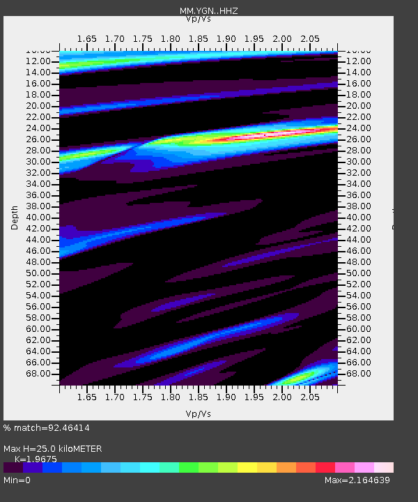
| Estimated Moho Depth: |
25.0 km |
| Estimated Crust Vp/Vs: |
1.97 |
| Assumed Crust Vp: |
6.287 km/s |
| Estimated Crust Vs: |
3.196 km/s |
| Estimated Crust Poisson's Ratio: |
0.33 |
|
| Radial Match: |
92.46414 % |
| Radial Bump: |
357 |
| Transverse Match: |
77.509476 % |
| Transverse Bump: |
400 |
| SOD ConfigId: |
25131211 |
| Insert Time: |
2021-08-12 06:28:11.682 +0000 |
| GWidth: |
2.5 |
| Max Bumps: |
400 |
| Tol: |
0.001 |
|

Signal To Noise
| Channel | StoN | STA | LTA |
| MM:YGN: :HHZ:20210729T06:27:50.767977Z | 6.001192 | 1.0516669E-5 | 1.7524301E-6 |
| MM:YGN: :HHN:20210729T06:27:50.767977Z | 1.4757541 | 3.9138877E-6 | 2.652127E-6 |
| MM:YGN: :HHE:20210729T06:27:50.767977Z | 0.99364763 | 3.4114132E-6 | 3.4332222E-6 |
| Arrivals |
| Ps | 3.9 SECOND |
| PpPs | 12 SECOND |
| PsPs/PpSs | 15 SECOND |


