You are here: Home > Network List > N4 - Central and EAstern US Network Stations List
> Station 250A Grady, AL, USA > Earthquake Result Viewer
250A Grady, AL, USA - Earthquake Result Viewer
| Earthquake location: |
Alaska Peninsula |
| Earthquake latitude/longitude: |
55.3/-157.8 |
| Earthquake time(UTC): |
2021/07/29 (210) 06:15:45 GMT |
| Earthquake Depth: |
5.2 km |
| Earthquake Magnitude: |
7.3 ml |
| Earthquake Catalog/Contributor: |
NEIC PDE/ak |
|
| Network: |
N4 Central and EAstern US Network |
| Station: |
250A Grady, AL, USA |
| Lat/Lon: |
31.98 N/86.27 W |
| Elevation: |
152 m |
|
| Distance: |
54.1 deg |
| Az: |
84.275 deg |
| Baz: |
317.977 deg |
| Ray Param: |
0.06566439 |
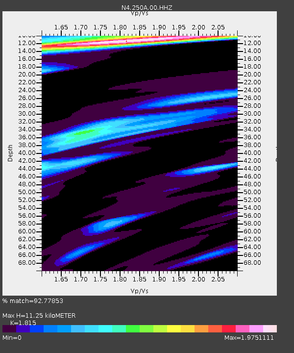
| Estimated Moho Depth: |
11.25 km |
| Estimated Crust Vp/Vs: |
1.82 |
| Assumed Crust Vp: |
6.187 km/s |
| Estimated Crust Vs: |
3.409 km/s |
| Estimated Crust Poisson's Ratio: |
0.28 |
|
| Radial Match: |
92.77853 % |
| Radial Bump: |
252 |
| Transverse Match: |
83.74995 % |
| Transverse Bump: |
399 |
| SOD ConfigId: |
25131211 |
| Insert Time: |
2021-08-12 06:28:34.999 +0000 |
| GWidth: |
2.5 |
| Max Bumps: |
400 |
| Tol: |
0.001 |
|

Signal To Noise
| Channel | StoN | STA | LTA |
| N4:250A:00:HHZ:20210729T06:24:40.280001Z | 9.808681 | 1.7767067E-6 | 1.8113614E-7 |
| N4:250A:00:HH1:20210729T06:24:40.280001Z | 3.799061 | 6.4964655E-7 | 1.7100187E-7 |
| N4:250A:00:HH2:20210729T06:24:40.280001Z | 4.202768 | 6.151082E-7 | 1.4635788E-7 |
| Arrivals |
| Ps | 1.6 SECOND |
| PpPs | 4.9 SECOND |
| PsPs/PpSs | 6.4 SECOND |


