You are here: Home > Network List > N4 - Central and EAstern US Network Stations List
> Station MSTX Muleshoe, TX, USA > Earthquake Result Viewer
MSTX Muleshoe, TX, USA - Earthquake Result Viewer
| Earthquake location: |
Alaska Peninsula |
| Earthquake latitude/longitude: |
55.3/-157.8 |
| Earthquake time(UTC): |
2021/07/29 (210) 06:15:45 GMT |
| Earthquake Depth: |
5.2 km |
| Earthquake Magnitude: |
7.3 ml |
| Earthquake Catalog/Contributor: |
NEIC PDE/ak |
|
| Network: |
N4 Central and EAstern US Network |
| Station: |
MSTX Muleshoe, TX, USA |
| Lat/Lon: |
33.97 N/102.77 W |
| Elevation: |
1167 m |
|
| Distance: |
43.2 deg |
| Az: |
96.076 deg |
| Baz: |
316.834 deg |
| Ray Param: |
0.072692834 |
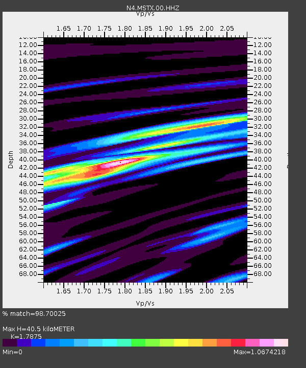
| Estimated Moho Depth: |
40.5 km |
| Estimated Crust Vp/Vs: |
1.79 |
| Assumed Crust Vp: |
6.129 km/s |
| Estimated Crust Vs: |
3.429 km/s |
| Estimated Crust Poisson's Ratio: |
0.27 |
|
| Radial Match: |
98.70025 % |
| Radial Bump: |
375 |
| Transverse Match: |
91.45933 % |
| Transverse Bump: |
400 |
| SOD ConfigId: |
25131211 |
| Insert Time: |
2021-08-12 06:29:37.317 +0000 |
| GWidth: |
2.5 |
| Max Bumps: |
400 |
| Tol: |
0.001 |
|

Signal To Noise
| Channel | StoN | STA | LTA |
| N4:MSTX:00:HHZ:20210729T06:23:16.748995Z | 6.8228593 | 2.0041466E-6 | 2.9374E-7 |
| N4:MSTX:00:HH1:20210729T06:23:16.748995Z | 5.2381763 | 9.3174253E-7 | 1.7787538E-7 |
| N4:MSTX:00:HH2:20210729T06:23:16.748995Z | 6.037054 | 9.703201E-7 | 1.6072741E-7 |
| Arrivals |
| Ps | 5.5 SECOND |
| PpPs | 17 SECOND |
| PsPs/PpSs | 23 SECOND |


