You are here: Home > Network List > N4 - Central and EAstern US Network Stations List
> Station N47A Urbana, IN, USA > Earthquake Result Viewer
N47A Urbana, IN, USA - Earthquake Result Viewer
| Earthquake location: |
Alaska Peninsula |
| Earthquake latitude/longitude: |
55.3/-157.8 |
| Earthquake time(UTC): |
2021/07/29 (210) 06:15:45 GMT |
| Earthquake Depth: |
5.2 km |
| Earthquake Magnitude: |
7.3 ml |
| Earthquake Catalog/Contributor: |
NEIC PDE/ak |
|
| Network: |
N4 Central and EAstern US Network |
| Station: |
N47A Urbana, IN, USA |
| Lat/Lon: |
40.88 N/85.69 W |
| Elevation: |
252 m |
|
| Distance: |
48.1 deg |
| Az: |
75.85 deg |
| Baz: |
313.015 deg |
| Ray Param: |
0.06960145 |
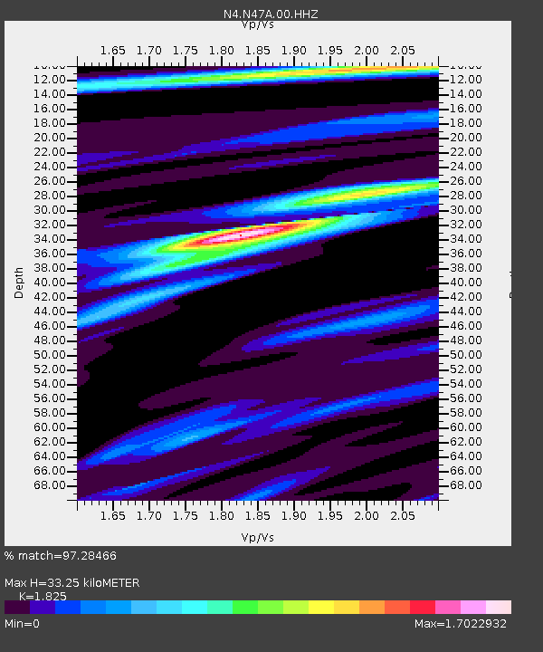
| Estimated Moho Depth: |
33.25 km |
| Estimated Crust Vp/Vs: |
1.83 |
| Assumed Crust Vp: |
6.498 km/s |
| Estimated Crust Vs: |
3.56 km/s |
| Estimated Crust Poisson's Ratio: |
0.29 |
|
| Radial Match: |
97.28466 % |
| Radial Bump: |
275 |
| Transverse Match: |
87.8189 % |
| Transverse Bump: |
400 |
| SOD ConfigId: |
25131211 |
| Insert Time: |
2021-08-12 06:29:42.680 +0000 |
| GWidth: |
2.5 |
| Max Bumps: |
400 |
| Tol: |
0.001 |
|

Signal To Noise
| Channel | StoN | STA | LTA |
| N4:N47A:00:HHZ:20210729T06:23:55.079989Z | 10.37048 | 2.283264E-6 | 2.2016955E-7 |
| N4:N47A:00:HH1:20210729T06:23:55.079989Z | 4.9394374 | 7.13253E-7 | 1.4439964E-7 |
| N4:N47A:00:HH2:20210729T06:23:55.079989Z | 6.1638937 | 8.846632E-7 | 1.4352344E-7 |
| Arrivals |
| Ps | 4.5 SECOND |
| PpPs | 14 SECOND |
| PsPs/PpSs | 18 SECOND |


