You are here: Home > Network List > N4 - Central and EAstern US Network Stations List
> Station N62A Caumsett State Park, Huntington, NY, USA > Earthquake Result Viewer
N62A Caumsett State Park, Huntington, NY, USA - Earthquake Result Viewer
| Earthquake location: |
Alaska Peninsula |
| Earthquake latitude/longitude: |
55.3/-157.8 |
| Earthquake time(UTC): |
2021/07/29 (210) 06:15:45 GMT |
| Earthquake Depth: |
5.2 km |
| Earthquake Magnitude: |
7.3 ml |
| Earthquake Catalog/Contributor: |
NEIC PDE/ak |
|
| Network: |
N4 Central and EAstern US Network |
| Station: |
N62A Caumsett State Park, Huntington, NY, USA |
| Lat/Lon: |
40.93 N/73.47 W |
| Elevation: |
34 m |
|
| Distance: |
54.7 deg |
| Az: |
67.515 deg |
| Baz: |
315.792 deg |
| Ray Param: |
0.06530271 |
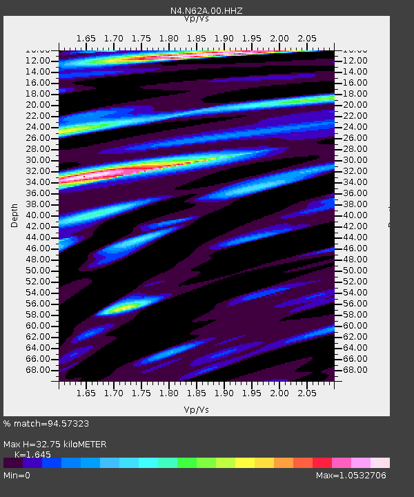
| Estimated Moho Depth: |
32.75 km |
| Estimated Crust Vp/Vs: |
1.64 |
| Assumed Crust Vp: |
6.472 km/s |
| Estimated Crust Vs: |
3.934 km/s |
| Estimated Crust Poisson's Ratio: |
0.21 |
|
| Radial Match: |
94.57323 % |
| Radial Bump: |
400 |
| Transverse Match: |
78.238754 % |
| Transverse Bump: |
400 |
| SOD ConfigId: |
25131211 |
| Insert Time: |
2021-08-12 06:29:48.290 +0000 |
| GWidth: |
2.5 |
| Max Bumps: |
400 |
| Tol: |
0.001 |
|

Signal To Noise
| Channel | StoN | STA | LTA |
| N4:N62A:00:HHZ:20210729T06:24:44.409029Z | 3.7381175 | 1.8617736E-6 | 4.980512E-7 |
| N4:N62A:00:HH1:20210729T06:24:44.409029Z | 3.336251 | 9.580612E-7 | 2.87167E-7 |
| N4:N62A:00:HH2:20210729T06:24:44.409029Z | 2.7432632 | 7.747985E-7 | 2.8243682E-7 |
| Arrivals |
| Ps | 3.5 SECOND |
| PpPs | 13 SECOND |
| PsPs/PpSs | 16 SECOND |


