You are here: Home > Network List > N4 - Central and EAstern US Network Stations List
> Station P38B Dawn, MO, USA > Earthquake Result Viewer
P38B Dawn, MO, USA - Earthquake Result Viewer
| Earthquake location: |
Alaska Peninsula |
| Earthquake latitude/longitude: |
55.3/-157.8 |
| Earthquake time(UTC): |
2021/07/29 (210) 06:15:45 GMT |
| Earthquake Depth: |
5.2 km |
| Earthquake Magnitude: |
7.3 ml |
| Earthquake Catalog/Contributor: |
NEIC PDE/ak |
|
| Network: |
N4 Central and EAstern US Network |
| Station: |
P38B Dawn, MO, USA |
| Lat/Lon: |
39.62 N/93.53 W |
| Elevation: |
248 m |
|
| Distance: |
44.5 deg |
| Az: |
82.761 deg |
| Baz: |
312.743 deg |
| Ray Param: |
0.071875006 |
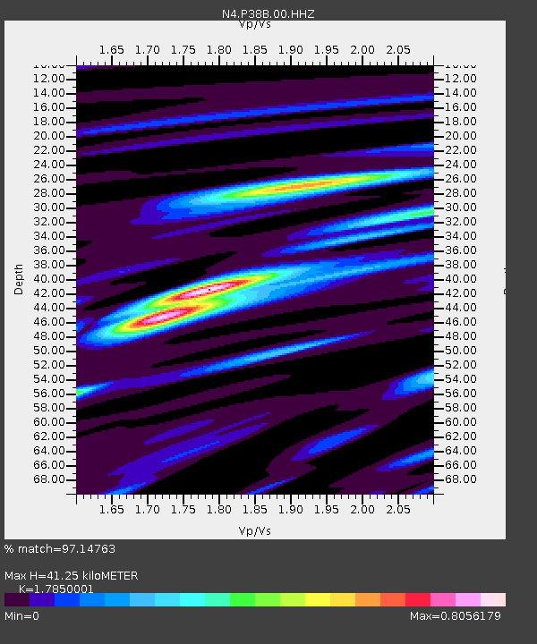
| Estimated Moho Depth: |
41.25 km |
| Estimated Crust Vp/Vs: |
1.79 |
| Assumed Crust Vp: |
6.498 km/s |
| Estimated Crust Vs: |
3.64 km/s |
| Estimated Crust Poisson's Ratio: |
0.27 |
|
| Radial Match: |
97.14763 % |
| Radial Bump: |
250 |
| Transverse Match: |
81.59489 % |
| Transverse Bump: |
400 |
| SOD ConfigId: |
25131211 |
| Insert Time: |
2021-08-12 06:29:55.935 +0000 |
| GWidth: |
2.5 |
| Max Bumps: |
400 |
| Tol: |
0.001 |
|

Signal To Noise
| Channel | StoN | STA | LTA |
| N4:P38B:00:HHZ:20210729T06:23:27.220003Z | 5.6550093 | 1.756091E-6 | 3.1053725E-7 |
| N4:P38B:00:HH1:20210729T06:23:27.220003Z | 4.246601 | 6.328307E-7 | 1.4902052E-7 |
| N4:P38B:00:HH2:20210729T06:23:27.220003Z | 4.8306103 | 8.805051E-7 | 1.8227615E-7 |
| Arrivals |
| Ps | 5.3 SECOND |
| PpPs | 17 SECOND |
| PsPs/PpSs | 22 SECOND |


