You are here: Home > Network List > N4 - Central and EAstern US Network Stations List
> Station W59A Clinton, NC, USA > Earthquake Result Viewer
W59A Clinton, NC, USA - Earthquake Result Viewer
| Earthquake location: |
Alaska Peninsula |
| Earthquake latitude/longitude: |
55.3/-157.8 |
| Earthquake time(UTC): |
2021/07/29 (210) 06:15:45 GMT |
| Earthquake Depth: |
5.2 km |
| Earthquake Magnitude: |
7.3 ml |
| Earthquake Catalog/Contributor: |
NEIC PDE/ak |
|
| Network: |
N4 Central and EAstern US Network |
| Station: |
W59A Clinton, NC, USA |
| Lat/Lon: |
35.17 N/78.44 W |
| Elevation: |
60 m |
|
| Distance: |
56.2 deg |
| Az: |
75.781 deg |
| Baz: |
317.43 deg |
| Ray Param: |
0.06433676 |
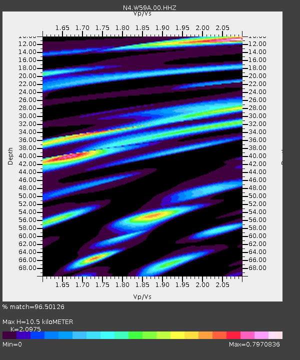
| Estimated Moho Depth: |
10.5 km |
| Estimated Crust Vp/Vs: |
2.10 |
| Assumed Crust Vp: |
6.565 km/s |
| Estimated Crust Vs: |
3.13 km/s |
| Estimated Crust Poisson's Ratio: |
0.35 |
|
| Radial Match: |
96.50126 % |
| Radial Bump: |
400 |
| Transverse Match: |
76.90825 % |
| Transverse Bump: |
400 |
| SOD ConfigId: |
25131211 |
| Insert Time: |
2021-08-12 06:30:44.905 +0000 |
| GWidth: |
2.5 |
| Max Bumps: |
400 |
| Tol: |
0.001 |
|

Signal To Noise
| Channel | StoN | STA | LTA |
| N4:W59A:00:HHZ:20210729T06:24:55.069002Z | 5.8933687 | 1.3564661E-6 | 2.3016823E-7 |
| N4:W59A:00:HH1:20210729T06:24:55.069002Z | 4.0061717 | 5.503216E-7 | 1.3736846E-7 |
| N4:W59A:00:HH2:20210729T06:24:55.069002Z | 3.7736237 | 5.81394E-7 | 1.5406782E-7 |
| Arrivals |
| Ps | 1.8 SECOND |
| PpPs | 4.7 SECOND |
| PsPs/PpSs | 6.6 SECOND |


