You are here: Home > Network List > N4 - Central and EAstern US Network Stations List
> Station X51A Calhoun, GA, USA > Earthquake Result Viewer
X51A Calhoun, GA, USA - Earthquake Result Viewer
| Earthquake location: |
Alaska Peninsula |
| Earthquake latitude/longitude: |
55.3/-157.8 |
| Earthquake time(UTC): |
2021/07/29 (210) 06:15:45 GMT |
| Earthquake Depth: |
5.2 km |
| Earthquake Magnitude: |
7.3 ml |
| Earthquake Catalog/Contributor: |
NEIC PDE/ak |
|
| Network: |
N4 Central and EAstern US Network |
| Station: |
X51A Calhoun, GA, USA |
| Lat/Lon: |
34.57 N/84.86 W |
| Elevation: |
214 m |
|
| Distance: |
53.0 deg |
| Az: |
81.023 deg |
| Baz: |
316.816 deg |
| Ray Param: |
0.06640192 |
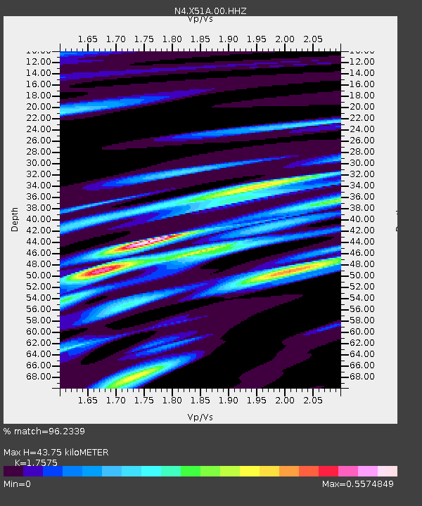
| Estimated Moho Depth: |
43.75 km |
| Estimated Crust Vp/Vs: |
1.76 |
| Assumed Crust Vp: |
6.35 km/s |
| Estimated Crust Vs: |
3.613 km/s |
| Estimated Crust Poisson's Ratio: |
0.26 |
|
| Radial Match: |
96.2339 % |
| Radial Bump: |
267 |
| Transverse Match: |
82.84146 % |
| Transverse Bump: |
400 |
| SOD ConfigId: |
25131211 |
| Insert Time: |
2021-08-12 06:30:48.531 +0000 |
| GWidth: |
2.5 |
| Max Bumps: |
400 |
| Tol: |
0.001 |
|

Signal To Noise
| Channel | StoN | STA | LTA |
| N4:X51A:00:HHZ:20210729T06:24:32.220003Z | 5.409474 | 1.605056E-6 | 2.9671202E-7 |
| N4:X51A:00:HH1:20210729T06:24:32.220003Z | 4.023516 | 5.4252934E-7 | 1.348396E-7 |
| N4:X51A:00:HH2:20210729T06:24:32.220003Z | 4.598477 | 6.2288643E-7 | 1.3545494E-7 |
| Arrivals |
| Ps | 5.5 SECOND |
| PpPs | 18 SECOND |
| PsPs/PpSs | 24 SECOND |


