You are here: Home > Network List > N4 - Central and EAstern US Network Stations List
> Station Y52A Lilburn, GA, USA > Earthquake Result Viewer
Y52A Lilburn, GA, USA - Earthquake Result Viewer
| Earthquake location: |
Alaska Peninsula |
| Earthquake latitude/longitude: |
55.3/-157.8 |
| Earthquake time(UTC): |
2021/07/29 (210) 06:15:45 GMT |
| Earthquake Depth: |
5.2 km |
| Earthquake Magnitude: |
7.3 ml |
| Earthquake Catalog/Contributor: |
NEIC PDE/ak |
|
| Network: |
N4 Central and EAstern US Network |
| Station: |
Y52A Lilburn, GA, USA |
| Lat/Lon: |
33.86 N/84.06 W |
| Elevation: |
286 m |
|
| Distance: |
54.0 deg |
| Az: |
81.016 deg |
| Baz: |
317.257 deg |
| Ray Param: |
0.065748945 |
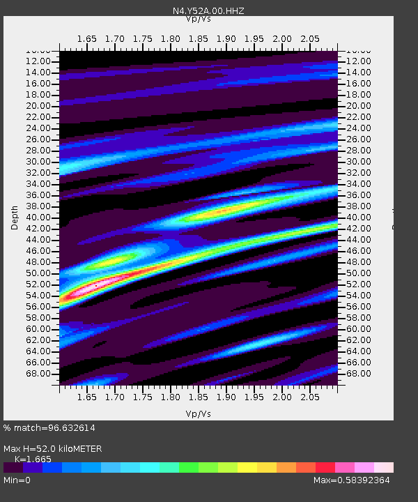
| Estimated Moho Depth: |
52.0 km |
| Estimated Crust Vp/Vs: |
1.66 |
| Assumed Crust Vp: |
6.719 km/s |
| Estimated Crust Vs: |
4.036 km/s |
| Estimated Crust Poisson's Ratio: |
0.22 |
|
| Radial Match: |
96.632614 % |
| Radial Bump: |
226 |
| Transverse Match: |
85.91493 % |
| Transverse Bump: |
400 |
| SOD ConfigId: |
25131211 |
| Insert Time: |
2021-08-12 06:30:52.921 +0000 |
| GWidth: |
2.5 |
| Max Bumps: |
400 |
| Tol: |
0.001 |
|

Signal To Noise
| Channel | StoN | STA | LTA |
| N4:Y52A:00:HHZ:20210729T06:24:39.269991Z | 8.343408 | 1.4635849E-6 | 1.7541814E-7 |
| N4:Y52A:00:HH1:20210729T06:24:39.269991Z | 7.040058 | 5.7994487E-7 | 8.2377845E-8 |
| N4:Y52A:00:HH2:20210729T06:24:39.269991Z | 8.053354 | 6.3415575E-7 | 7.87443E-8 |
| Arrivals |
| Ps | 5.5 SECOND |
| PpPs | 19 SECOND |
| PsPs/PpSs | 25 SECOND |


