You are here: Home > Network List > NN - Western Great Basin/Eastern Sierra Nevada Stations List
> Station MCA06 Monte Cristo ASL 06 > Earthquake Result Viewer
MCA06 Monte Cristo ASL 06 - Earthquake Result Viewer
| Earthquake location: |
Alaska Peninsula |
| Earthquake latitude/longitude: |
55.3/-157.8 |
| Earthquake time(UTC): |
2021/07/29 (210) 06:15:45 GMT |
| Earthquake Depth: |
5.2 km |
| Earthquake Magnitude: |
7.3 ml |
| Earthquake Catalog/Contributor: |
NEIC PDE/ak |
|
| Network: |
NN Western Great Basin/Eastern Sierra Nevada |
| Station: |
MCA06 Monte Cristo ASL 06 |
| Lat/Lon: |
38.01 N/117.88 W |
| Elevation: |
1462 m |
|
| Distance: |
31.9 deg |
| Az: |
106.08 deg |
| Baz: |
315.932 deg |
| Ray Param: |
0.078920096 |
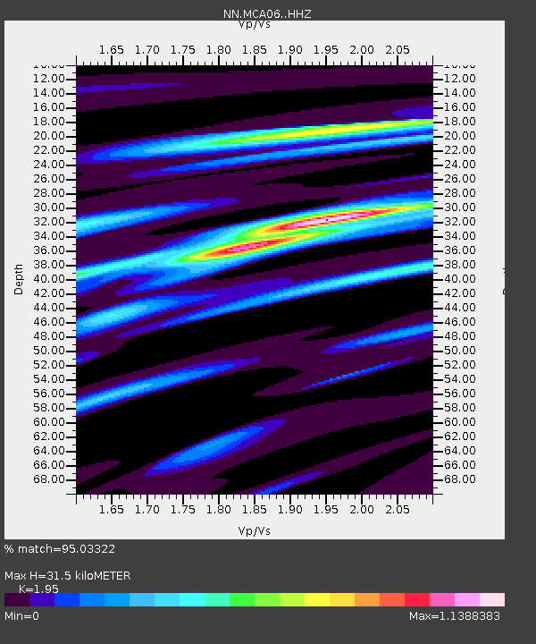
| Estimated Moho Depth: |
31.5 km |
| Estimated Crust Vp/Vs: |
1.95 |
| Assumed Crust Vp: |
6.276 km/s |
| Estimated Crust Vs: |
3.218 km/s |
| Estimated Crust Poisson's Ratio: |
0.32 |
|
| Radial Match: |
95.03322 % |
| Radial Bump: |
279 |
| Transverse Match: |
79.248764 % |
| Transverse Bump: |
400 |
| SOD ConfigId: |
25131211 |
| Insert Time: |
2021-08-12 06:31:43.947 +0000 |
| GWidth: |
2.5 |
| Max Bumps: |
400 |
| Tol: |
0.001 |
|

Signal To Noise
| Channel | StoN | STA | LTA |
| NN:MCA06: :HHZ:20210729T06:21:40.660006Z | 6.6997786 | 4.0022583E-6 | 5.973717E-7 |
| NN:MCA06: :HHN:20210729T06:21:40.660006Z | 8.593351 | 2.1263863E-6 | 2.474455E-7 |
| NN:MCA06: :HHE:20210729T06:21:40.660006Z | 9.416682 | 2.0232394E-6 | 2.1485694E-7 |
| Arrivals |
| Ps | 5.1 SECOND |
| PpPs | 14 SECOND |
| PsPs/PpSs | 19 SECOND |


