You are here: Home > Network List > NN - Western Great Basin/Eastern Sierra Nevada Stations List
> Station MCM05 Monte Cristo Menlo 05 > Earthquake Result Viewer
MCM05 Monte Cristo Menlo 05 - Earthquake Result Viewer
| Earthquake location: |
Alaska Peninsula |
| Earthquake latitude/longitude: |
55.3/-157.8 |
| Earthquake time(UTC): |
2021/07/29 (210) 06:15:45 GMT |
| Earthquake Depth: |
5.2 km |
| Earthquake Magnitude: |
7.3 ml |
| Earthquake Catalog/Contributor: |
NEIC PDE/ak |
|
| Network: |
NN Western Great Basin/Eastern Sierra Nevada |
| Station: |
MCM05 Monte Cristo Menlo 05 |
| Lat/Lon: |
38.16 N/117.87 W |
| Elevation: |
1591 m |
|
| Distance: |
31.8 deg |
| Az: |
105.874 deg |
| Baz: |
315.763 deg |
| Ray Param: |
0.0789606 |
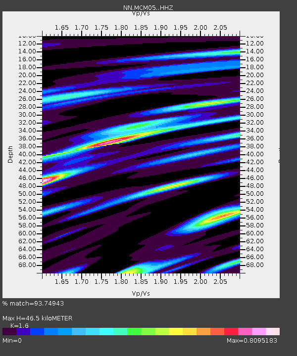
| Estimated Moho Depth: |
46.5 km |
| Estimated Crust Vp/Vs: |
1.60 |
| Assumed Crust Vp: |
6.276 km/s |
| Estimated Crust Vs: |
3.922 km/s |
| Estimated Crust Poisson's Ratio: |
0.18 |
|
| Radial Match: |
93.74943 % |
| Radial Bump: |
400 |
| Transverse Match: |
78.3883 % |
| Transverse Bump: |
400 |
| SOD ConfigId: |
25131211 |
| Insert Time: |
2021-08-12 06:31:46.834 +0000 |
| GWidth: |
2.5 |
| Max Bumps: |
400 |
| Tol: |
0.001 |
|

Signal To Noise
| Channel | StoN | STA | LTA |
| NN:MCM05: :HHZ:20210729T06:21:39.774996Z | 6.590544 | 4.0780424E-6 | 6.187717E-7 |
| NN:MCM05: :HHN:20210729T06:21:39.774996Z | 9.254537 | 2.2575375E-6 | 2.4393847E-7 |
| NN:MCM05: :HHE:20210729T06:21:39.774996Z | 9.264994 | 1.9583752E-6 | 2.1137362E-7 |
| Arrivals |
| Ps | 4.8 SECOND |
| PpPs | 18 SECOND |
| PsPs/PpSs | 23 SECOND |


