You are here: Home > Network List > NN - Western Great Basin/Eastern Sierra Nevada Stations List
> Station MCM08 Monte Cristo Menlo 08 > Earthquake Result Viewer
MCM08 Monte Cristo Menlo 08 - Earthquake Result Viewer
| Earthquake location: |
Alaska Peninsula |
| Earthquake latitude/longitude: |
55.3/-157.8 |
| Earthquake time(UTC): |
2021/07/29 (210) 06:15:45 GMT |
| Earthquake Depth: |
5.2 km |
| Earthquake Magnitude: |
7.3 ml |
| Earthquake Catalog/Contributor: |
NEIC PDE/ak |
|
| Network: |
NN Western Great Basin/Eastern Sierra Nevada |
| Station: |
MCM08 Monte Cristo Menlo 08 |
| Lat/Lon: |
38.16 N/118.05 W |
| Elevation: |
1669 m |
|
| Distance: |
31.7 deg |
| Az: |
106.064 deg |
| Baz: |
315.814 deg |
| Ray Param: |
0.079000294 |
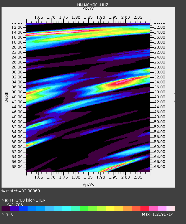
| Estimated Moho Depth: |
14.0 km |
| Estimated Crust Vp/Vs: |
1.71 |
| Assumed Crust Vp: |
6.279 km/s |
| Estimated Crust Vs: |
3.682 km/s |
| Estimated Crust Poisson's Ratio: |
0.24 |
|
| Radial Match: |
92.98968 % |
| Radial Bump: |
400 |
| Transverse Match: |
84.57044 % |
| Transverse Bump: |
400 |
| SOD ConfigId: |
25131211 |
| Insert Time: |
2021-08-12 06:31:49.784 +0000 |
| GWidth: |
2.5 |
| Max Bumps: |
400 |
| Tol: |
0.001 |
|

Signal To Noise
| Channel | StoN | STA | LTA |
| NN:MCM08: :HHZ:20210729T06:21:38.889986Z | 6.894857 | 4.0986874E-6 | 5.9445574E-7 |
| NN:MCM08: :HHN:20210729T06:21:38.889986Z | 8.902839 | 2.1391777E-6 | 2.402804E-7 |
| NN:MCM08: :HHE:20210729T06:21:38.889986Z | 9.343484 | 2.1880949E-6 | 2.3418404E-7 |
| Arrivals |
| Ps | 1.7 SECOND |
| PpPs | 5.6 SECOND |
| PsPs/PpSs | 7.3 SECOND |


