You are here: Home > Network List > O2 - Oklahoma Consolidated Temporary Seismic Networks Stations List
> Station CRES Cresent, Oklahoma, USA > Earthquake Result Viewer
CRES Cresent, Oklahoma, USA - Earthquake Result Viewer
| Earthquake location: |
Alaska Peninsula |
| Earthquake latitude/longitude: |
55.3/-157.8 |
| Earthquake time(UTC): |
2021/07/29 (210) 06:15:45 GMT |
| Earthquake Depth: |
5.2 km |
| Earthquake Magnitude: |
7.3 ml |
| Earthquake Catalog/Contributor: |
NEIC PDE/ak |
|
| Network: |
O2 Oklahoma Consolidated Temporary Seismic Networks |
| Station: |
CRES Cresent, Oklahoma, USA |
| Lat/Lon: |
36.04 N/97.53 W |
| Elevation: |
311 m |
|
| Distance: |
44.8 deg |
| Az: |
89.561 deg |
| Baz: |
315.137 deg |
| Ray Param: |
0.07174428 |
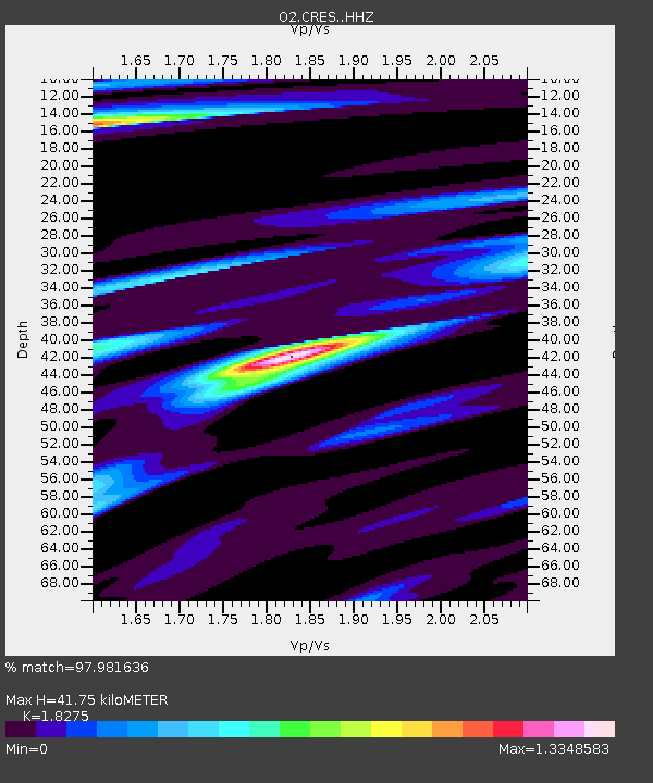
| Estimated Moho Depth: |
41.75 km |
| Estimated Crust Vp/Vs: |
1.83 |
| Assumed Crust Vp: |
6.483 km/s |
| Estimated Crust Vs: |
3.547 km/s |
| Estimated Crust Poisson's Ratio: |
0.29 |
|
| Radial Match: |
97.981636 % |
| Radial Bump: |
293 |
| Transverse Match: |
89.803604 % |
| Transverse Bump: |
400 |
| SOD ConfigId: |
25131211 |
| Insert Time: |
2021-08-12 06:32:31.903 +0000 |
| GWidth: |
2.5 |
| Max Bumps: |
400 |
| Tol: |
0.001 |
|

Signal To Noise
| Channel | StoN | STA | LTA |
| O2:CRES: :HHZ:20210729T06:23:28.834994Z | 6.3373823 | 1.7324501E-6 | 2.7336998E-7 |
| O2:CRES: :HHN:20210729T06:23:28.834994Z | 4.8265653 | 6.6312543E-7 | 1.3739074E-7 |
| O2:CRES: :HHE:20210729T06:23:28.834994Z | 6.6458054 | 1.1028816E-6 | 1.6595153E-7 |
| Arrivals |
| Ps | 5.7 SECOND |
| PpPs | 17 SECOND |
| PsPs/PpSs | 23 SECOND |


