You are here: Home > Network List > O2 - Oklahoma Consolidated Temporary Seismic Networks Stations List
> Station SC12 Granite, Oklahoma, USA > Earthquake Result Viewer
SC12 Granite, Oklahoma, USA - Earthquake Result Viewer
| Earthquake location: |
Alaska Peninsula |
| Earthquake latitude/longitude: |
55.3/-157.8 |
| Earthquake time(UTC): |
2021/07/29 (210) 06:15:45 GMT |
| Earthquake Depth: |
5.2 km |
| Earthquake Magnitude: |
7.3 ml |
| Earthquake Catalog/Contributor: |
NEIC PDE/ak |
|
| Network: |
O2 Oklahoma Consolidated Temporary Seismic Networks |
| Station: |
SC12 Granite, Oklahoma, USA |
| Lat/Lon: |
34.92 N/99.35 W |
| Elevation: |
472 m |
|
| Distance: |
44.5 deg |
| Az: |
92.18 deg |
| Baz: |
315.949 deg |
| Ray Param: |
0.071903 |
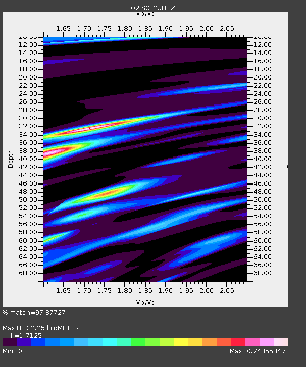
| Estimated Moho Depth: |
32.25 km |
| Estimated Crust Vp/Vs: |
1.71 |
| Assumed Crust Vp: |
6.315 km/s |
| Estimated Crust Vs: |
3.688 km/s |
| Estimated Crust Poisson's Ratio: |
0.24 |
|
| Radial Match: |
97.87727 % |
| Radial Bump: |
234 |
| Transverse Match: |
91.398705 % |
| Transverse Bump: |
400 |
| SOD ConfigId: |
25131211 |
| Insert Time: |
2021-08-12 06:33:30.510 +0000 |
| GWidth: |
2.5 |
| Max Bumps: |
400 |
| Tol: |
0.001 |
|

Signal To Noise
| Channel | StoN | STA | LTA |
| O2:SC12: :HHZ:20210729T06:23:26.875002Z | 6.4777665 | 1.7688577E-6 | 2.7306598E-7 |
| O2:SC12: :HHN:20210729T06:23:26.875002Z | 5.6702437 | 7.5532836E-7 | 1.3320916E-7 |
| O2:SC12: :HHE:20210729T06:23:26.875002Z | 4.7131557 | 9.638354E-7 | 2.0449895E-7 |
| Arrivals |
| Ps | 3.9 SECOND |
| PpPs | 13 SECOND |
| PsPs/PpSs | 17 SECOND |


