You are here: Home > Network List > O2 - Oklahoma Consolidated Temporary Seismic Networks Stations List
> Station SC14 Walters, Oklahoma, USA > Earthquake Result Viewer
SC14 Walters, Oklahoma, USA - Earthquake Result Viewer
| Earthquake location: |
Alaska Peninsula |
| Earthquake latitude/longitude: |
55.3/-157.8 |
| Earthquake time(UTC): |
2021/07/29 (210) 06:15:45 GMT |
| Earthquake Depth: |
5.2 km |
| Earthquake Magnitude: |
7.3 ml |
| Earthquake Catalog/Contributor: |
NEIC PDE/ak |
|
| Network: |
O2 Oklahoma Consolidated Temporary Seismic Networks |
| Station: |
SC14 Walters, Oklahoma, USA |
| Lat/Lon: |
34.45 N/98.24 W |
| Elevation: |
339 m |
|
| Distance: |
45.5 deg |
| Az: |
91.707 deg |
| Baz: |
316.244 deg |
| Ray Param: |
0.07127174 |
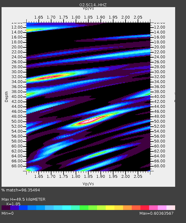
| Estimated Moho Depth: |
49.5 km |
| Estimated Crust Vp/Vs: |
1.85 |
| Assumed Crust Vp: |
6.315 km/s |
| Estimated Crust Vs: |
3.414 km/s |
| Estimated Crust Poisson's Ratio: |
0.29 |
|
| Radial Match: |
96.35494 % |
| Radial Bump: |
400 |
| Transverse Match: |
96.35494 % |
| Transverse Bump: |
400 |
| SOD ConfigId: |
25131211 |
| Insert Time: |
2021-08-12 06:33:33.918 +0000 |
| GWidth: |
2.5 |
| Max Bumps: |
400 |
| Tol: |
0.001 |
|

Signal To Noise
| Channel | StoN | STA | LTA |
| O2:SC14: :HHZ:20210729T06:23:34.595003Z | 6.7349777 | 1.7802982E-6 | 2.6433617E-7 |
| $trig.getChannelId() | $trig.getValue() | $trig.getSTA() | $trig.getLTA() |
| O2:SC14: :HHE:20210729T06:23:34.595003Z | 9.183859 | 1.0701901E-6 | 1.16529456E-7 |
| Arrivals |
| Ps | 7.1 SECOND |
| PpPs | 21 SECOND |
| PsPs/PpSs | 28 SECOND |


