You are here: Home > Network List > PE - Penn State Network Stations List
> Station PAMR Moraine State Park, Slippery Rock, PA > Earthquake Result Viewer
PAMR Moraine State Park, Slippery Rock, PA - Earthquake Result Viewer
| Earthquake location: |
Alaska Peninsula |
| Earthquake latitude/longitude: |
55.3/-157.8 |
| Earthquake time(UTC): |
2021/07/29 (210) 06:15:45 GMT |
| Earthquake Depth: |
5.2 km |
| Earthquake Magnitude: |
7.3 ml |
| Earthquake Catalog/Contributor: |
NEIC PDE/ak |
|
| Network: |
PE Penn State Network |
| Station: |
PAMR Moraine State Park, Slippery Rock, PA |
| Lat/Lon: |
40.94 N/80.10 W |
| Elevation: |
393 m |
|
| Distance: |
51.1 deg |
| Az: |
71.955 deg |
| Baz: |
314.143 deg |
| Ray Param: |
0.0676283 |
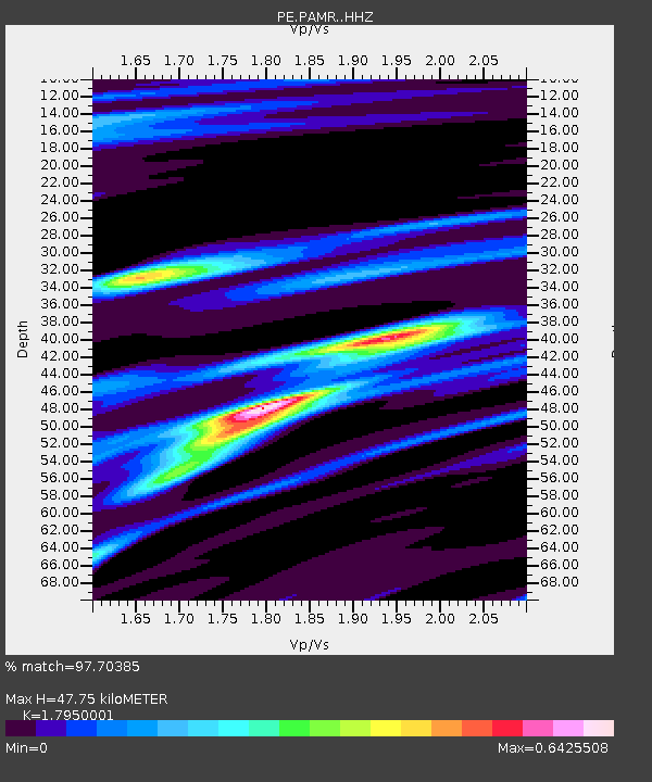
| Estimated Moho Depth: |
47.75 km |
| Estimated Crust Vp/Vs: |
1.80 |
| Assumed Crust Vp: |
6.483 km/s |
| Estimated Crust Vs: |
3.611 km/s |
| Estimated Crust Poisson's Ratio: |
0.27 |
|
| Radial Match: |
97.70385 % |
| Radial Bump: |
256 |
| Transverse Match: |
75.55334 % |
| Transverse Bump: |
400 |
| SOD ConfigId: |
25131211 |
| Insert Time: |
2021-08-12 06:35:21.395 +0000 |
| GWidth: |
2.5 |
| Max Bumps: |
400 |
| Tol: |
0.001 |
|

Signal To Noise
| Channel | StoN | STA | LTA |
| PE:PAMR: :HHZ:20210729T06:24:18.160006Z | 7.138067 | 1.9301897E-6 | 2.7040792E-7 |
| PE:PAMR: :HHN:20210729T06:24:18.160006Z | 4.2089424 | 5.873452E-7 | 1.3954698E-7 |
| PE:PAMR: :HHE:20210729T06:24:18.160006Z | 6.510841 | 7.310156E-7 | 1.1227668E-7 |
| Arrivals |
| Ps | 6.2 SECOND |
| PpPs | 19 SECOND |
| PsPs/PpSs | 26 SECOND |


