You are here: Home > Network List > PR - Puerto Rico Seismic Network (PRSN) & Puerto Rico Strong Motion Program (PRSMP) Stations List
> Station MTP MTP > Earthquake Result Viewer
MTP MTP - Earthquake Result Viewer
| Earthquake location: |
Alaska Peninsula |
| Earthquake latitude/longitude: |
55.3/-157.8 |
| Earthquake time(UTC): |
2021/07/29 (210) 06:15:45 GMT |
| Earthquake Depth: |
5.2 km |
| Earthquake Magnitude: |
7.3 ml |
| Earthquake Catalog/Contributor: |
NEIC PDE/ak |
|
| Network: |
PR Puerto Rico Seismic Network (PRSN) & Puerto Rico Strong Motion Program (PRSMP) |
| Station: |
MTP MTP |
| Lat/Lon: |
18.10 N/65.55 W |
| Elevation: |
192 m |
|
| Distance: |
76.6 deg |
| Az: |
77.681 deg |
| Baz: |
324.035 deg |
| Ray Param: |
0.05089969 |
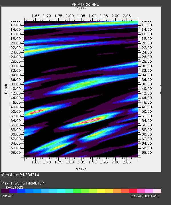
| Estimated Moho Depth: |
53.75 km |
| Estimated Crust Vp/Vs: |
1.89 |
| Assumed Crust Vp: |
5.14 km/s |
| Estimated Crust Vs: |
2.716 km/s |
| Estimated Crust Poisson's Ratio: |
0.31 |
|
| Radial Match: |
94.336716 % |
| Radial Bump: |
400 |
| Transverse Match: |
90.93646 % |
| Transverse Bump: |
400 |
| SOD ConfigId: |
25131211 |
| Insert Time: |
2021-08-12 06:36:26.293 +0000 |
| GWidth: |
2.5 |
| Max Bumps: |
400 |
| Tol: |
0.001 |
|

Signal To Noise
| Channel | StoN | STA | LTA |
| PR:MTP:00:HHZ:20210729T06:27:05.579989Z | 6.2771974 | 1.1335658E-6 | 1.8058469E-7 |
| PR:MTP:00:HH1:20210729T06:27:05.579989Z | 2.0024104 | 3.8974014E-7 | 1.9463549E-7 |
| PR:MTP:00:HH2:20210729T06:27:05.579989Z | 2.0718353 | 2.5899536E-7 | 1.2500769E-7 |
| Arrivals |
| Ps | 9.5 SECOND |
| PpPs | 30 SECOND |
| PsPs/PpSs | 39 SECOND |


