You are here: Home > Network List > PY - PFO Array Stations List
> Station TPFO Pinon Flats, CA, USA > Earthquake Result Viewer
TPFO Pinon Flats, CA, USA - Earthquake Result Viewer
| Earthquake location: |
Alaska Peninsula |
| Earthquake latitude/longitude: |
55.3/-157.8 |
| Earthquake time(UTC): |
2021/07/29 (210) 06:15:45 GMT |
| Earthquake Depth: |
5.2 km |
| Earthquake Magnitude: |
7.3 ml |
| Earthquake Catalog/Contributor: |
NEIC PDE/ak |
|
| Network: |
PY PFO Array |
| Station: |
TPFO Pinon Flats, CA, USA |
| Lat/Lon: |
33.61 N/116.45 W |
| Elevation: |
1275 m |
|
| Distance: |
35.9 deg |
| Az: |
109.818 deg |
| Baz: |
319.87 deg |
| Ray Param: |
0.076999865 |
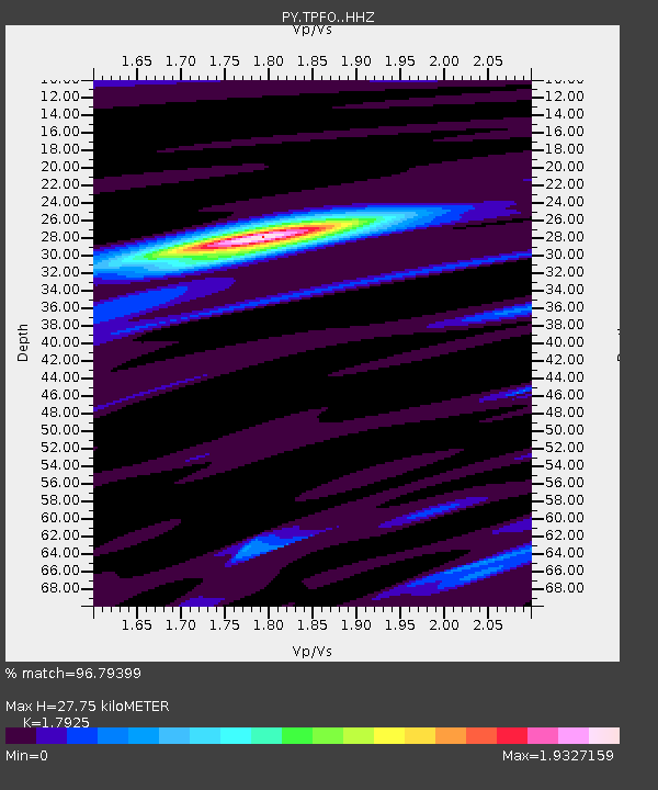
| Estimated Moho Depth: |
27.75 km |
| Estimated Crust Vp/Vs: |
1.79 |
| Assumed Crust Vp: |
6.264 km/s |
| Estimated Crust Vs: |
3.494 km/s |
| Estimated Crust Poisson's Ratio: |
0.27 |
|
| Radial Match: |
96.79399 % |
| Radial Bump: |
251 |
| Transverse Match: |
92.750824 % |
| Transverse Bump: |
400 |
| SOD ConfigId: |
25131211 |
| Insert Time: |
2021-08-12 06:36:56.870 +0000 |
| GWidth: |
2.5 |
| Max Bumps: |
400 |
| Tol: |
0.001 |
|

Signal To Noise
| Channel | StoN | STA | LTA |
| PY:TPFO: :HHZ:20210729T06:22:15.657992Z | 5.8955235 | 3.4797556E-6 | 5.9023694E-7 |
| PY:TPFO: :HHN:20210729T06:22:15.657992Z | 6.116586 | 1.9969868E-6 | 3.2648717E-7 |
| PY:TPFO: :HHE:20210729T06:22:15.657992Z | 6.15849 | 2.0146058E-6 | 3.2712657E-7 |
| Arrivals |
| Ps | 3.8 SECOND |
| PpPs | 12 SECOND |
| PsPs/PpSs | 15 SECOND |


