You are here: Home > Network List > SV - Servicio Nacional de Estudios Territoriales (SNET), El Salvador Stations List
> Station NUBE Z > Earthquake Result Viewer
NUBE Z - Earthquake Result Viewer
| Earthquake location: |
Alaska Peninsula |
| Earthquake latitude/longitude: |
55.3/-157.8 |
| Earthquake time(UTC): |
2021/07/29 (210) 06:15:45 GMT |
| Earthquake Depth: |
5.2 km |
| Earthquake Magnitude: |
7.3 ml |
| Earthquake Catalog/Contributor: |
NEIC PDE/ak |
|
| Network: |
SV Servicio Nacional de Estudios Territoriales (SNET), El Salvador |
| Station: |
NUBE Z |
| Lat/Lon: |
13.90 N/89.78 W |
| Elevation: |
1306 m |
|
| Distance: |
66.2 deg |
| Az: |
100.152 deg |
| Baz: |
324.58 deg |
| Ray Param: |
0.05778091 |
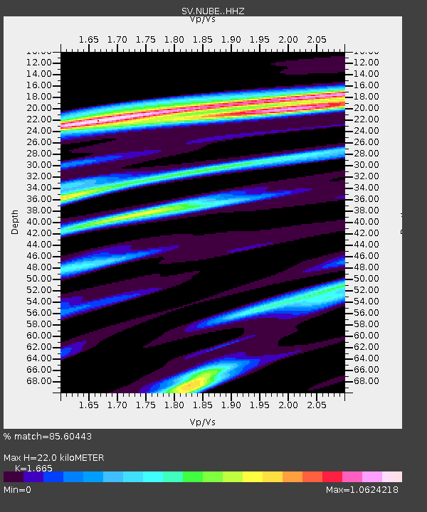
| Estimated Moho Depth: |
22.0 km |
| Estimated Crust Vp/Vs: |
1.66 |
| Assumed Crust Vp: |
6.048 km/s |
| Estimated Crust Vs: |
3.632 km/s |
| Estimated Crust Poisson's Ratio: |
0.22 |
|
| Radial Match: |
85.60443 % |
| Radial Bump: |
384 |
| Transverse Match: |
78.83903 % |
| Transverse Bump: |
400 |
| SOD ConfigId: |
25131211 |
| Insert Time: |
2021-08-12 06:37:33.509 +0000 |
| GWidth: |
2.5 |
| Max Bumps: |
400 |
| Tol: |
0.001 |
|

Signal To Noise
| Channel | StoN | STA | LTA |
| SV:NUBE: :HHZ:20210729T06:26:02.970003Z | 3.9286885 | 1.203724E-6 | 3.0639333E-7 |
| SV:NUBE: :HHN:20210729T06:26:02.970003Z | 1.3423446 | 5.3346076E-7 | 3.9740968E-7 |
| SV:NUBE: :HHE:20210729T06:26:02.970003Z | 0.68880177 | 1.57532E-7 | 2.287044E-7 |
| Arrivals |
| Ps | 2.5 SECOND |
| PpPs | 9.3 SECOND |
| PsPs/PpSs | 12 SECOND |


