You are here: Home > Network List > TC - Red Sismólogica Nacional de Costa Rica Stations List
> Station MARA Maravilla > Earthquake Result Viewer
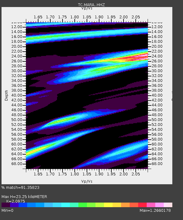
MARA Maravilla - Earthquake Result Viewer
| Earthquake location: |
Alaska Peninsula |
| Earthquake latitude/longitude: |
55.3/-157.8 |
| Earthquake time(UTC): |
2021/07/29 (210) 06:15:45 GMT |
| Earthquake Depth: |
5.2 km |
| Earthquake Magnitude: |
7.3 ml |
| Earthquake Catalog/Contributor: |
NEIC PDE/ak |
|
| Network: |
TC Red Sismólogica Nacional de Costa Rica |
| Station: |
MARA Maravilla |
| Lat/Lon: |
10.02 N/85.43 W |
| Elevation: |
629 m |
|
| Distance: |
71.8 deg |
| Az: |
98.805 deg |
| Baz: |
324.994 deg |
| Ray Param: |
0.05409562 |
| Estimated Moho Depth: |
23.25 km |
| Estimated Crust Vp/Vs: |
2.10 |
| Assumed Crust Vp: |
6.597 km/s |
| Estimated Crust Vs: |
3.145 km/s |
| Estimated Crust Poisson's Ratio: |
0.35 |
|
| Radial Match: |
91.35823 % |
| Radial Bump: |
362 |
| Transverse Match: |
91.7265 % |
| Transverse Bump: |
400 |
| SOD ConfigId: |
25131211 |
| Insert Time: |
2021-08-12 06:37:45.938 +0000 |
| GWidth: |
2.5 |
| Max Bumps: |
400 |
| Tol: |
0.001 |
|

Signal To Noise
| Channel | StoN | STA | LTA |
| TC:MARA: :HHZ:20210729T06:26:37.740023Z | 2.6459947 | 2.6276116E-6 | 9.930526E-7 |
| TC:MARA: :HHN:20210729T06:26:37.740023Z | 1.5532811 | 5.5194873E-6 | 3.5534376E-6 |
| TC:MARA: :HHE:20210729T06:26:37.740023Z | 0.73960114 | 3.7540717E-6 | 5.0758063E-6 |
| Arrivals |
| Ps | 4.0 SECOND |
| PpPs | 11 SECOND |
| PsPs/PpSs | 15 SECOND |


