You are here: Home > Network List > TX - Texas Seismological Network Stations List
> Station MB04 Seminole > Earthquake Result Viewer
MB04 Seminole - Earthquake Result Viewer
| Earthquake location: |
Alaska Peninsula |
| Earthquake latitude/longitude: |
55.3/-157.8 |
| Earthquake time(UTC): |
2021/07/29 (210) 06:15:45 GMT |
| Earthquake Depth: |
5.2 km |
| Earthquake Magnitude: |
7.3 ml |
| Earthquake Catalog/Contributor: |
NEIC PDE/ak |
|
| Network: |
TX Texas Seismological Network |
| Station: |
MB04 Seminole |
| Lat/Lon: |
32.63 N/102.49 W |
| Elevation: |
956 m |
|
| Distance: |
44.4 deg |
| Az: |
97.136 deg |
| Baz: |
317.754 deg |
| Ray Param: |
0.07197519 |
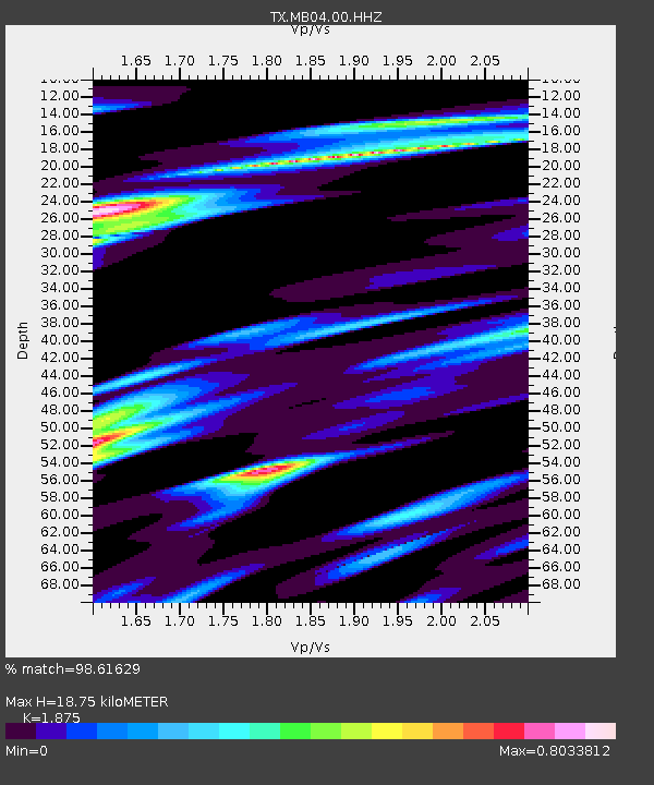
| Estimated Moho Depth: |
18.75 km |
| Estimated Crust Vp/Vs: |
1.88 |
| Assumed Crust Vp: |
6.129 km/s |
| Estimated Crust Vs: |
3.269 km/s |
| Estimated Crust Poisson's Ratio: |
0.30 |
|
| Radial Match: |
98.61629 % |
| Radial Bump: |
230 |
| Transverse Match: |
94.053085 % |
| Transverse Bump: |
400 |
| SOD ConfigId: |
25131211 |
| Insert Time: |
2021-08-12 06:38:37.592 +0000 |
| GWidth: |
2.5 |
| Max Bumps: |
400 |
| Tol: |
0.001 |
|

Signal To Noise
| Channel | StoN | STA | LTA |
| TX:MB04:00:HHZ:20210729T06:23:25.959994Z | 7.1162944 | 1.0177786E-6 | 1.4302087E-7 |
| TX:MB04:00:HH1:20210729T06:23:25.959994Z | 5.1462884 | 5.0642296E-7 | 9.8405486E-8 |
| TX:MB04:00:HH2:20210729T06:23:25.959994Z | 7.2759943 | 5.460769E-7 | 7.505185E-8 |
| Arrivals |
| Ps | 2.8 SECOND |
| PpPs | 8.3 SECOND |
| PsPs/PpSs | 11 SECOND |


