You are here: Home > Network List > TX - Texas Seismological Network Stations List
> Station RTBA Rita Blanca > Earthquake Result Viewer
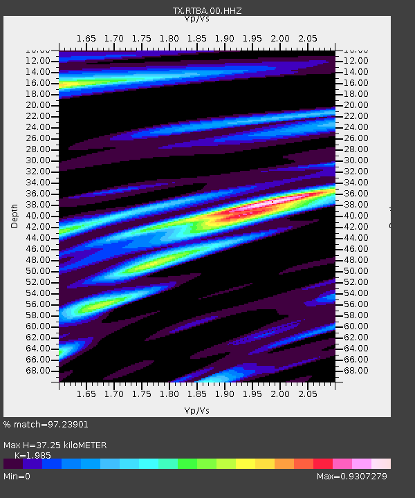
RTBA Rita Blanca - Earthquake Result Viewer
| Earthquake location: |
Alaska Peninsula |
| Earthquake latitude/longitude: |
55.3/-157.8 |
| Earthquake time(UTC): |
2021/07/29 (210) 06:15:45 GMT |
| Earthquake Depth: |
5.2 km |
| Earthquake Magnitude: |
7.3 ml |
| Earthquake Catalog/Contributor: |
NEIC PDE/ak |
|
| Network: |
TX Texas Seismological Network |
| Station: |
RTBA Rita Blanca |
| Lat/Lon: |
36.44 N/102.74 W |
| Elevation: |
1284 m |
|
| Distance: |
41.5 deg |
| Az: |
93.502 deg |
| Baz: |
314.952 deg |
| Ray Param: |
0.07377115 |
| Estimated Moho Depth: |
37.25 km |
| Estimated Crust Vp/Vs: |
1.99 |
| Assumed Crust Vp: |
6.306 km/s |
| Estimated Crust Vs: |
3.177 km/s |
| Estimated Crust Poisson's Ratio: |
0.33 |
|
| Radial Match: |
97.23901 % |
| Radial Bump: |
345 |
| Transverse Match: |
92.13147 % |
| Transverse Bump: |
400 |
| SOD ConfigId: |
25131211 |
| Insert Time: |
2021-08-12 06:39:09.329 +0000 |
| GWidth: |
2.5 |
| Max Bumps: |
400 |
| Tol: |
0.001 |
|

Signal To Noise
| Channel | StoN | STA | LTA |
| TX:RTBA:00:HHZ:20210729T06:23:02.530001Z | 7.0012093 | 2.017066E-6 | 2.881025E-7 |
| TX:RTBA:00:HH1:20210729T06:23:02.530001Z | 7.0806704 | 1.0971526E-6 | 1.5495038E-7 |
| TX:RTBA:00:HH2:20210729T06:23:02.530001Z | 4.716177 | 8.2826125E-7 | 1.7562132E-7 |
| Arrivals |
| Ps | 6.2 SECOND |
| PpPs | 17 SECOND |
| PsPs/PpSs | 23 SECOND |


