You are here: Home > Network List > US - United States National Seismic Network Stations List
> Station HWUT Hardware Ranch, Cache County, Utah, USA > Earthquake Result Viewer
HWUT Hardware Ranch, Cache County, Utah, USA - Earthquake Result Viewer
| Earthquake location: |
Alaska Peninsula |
| Earthquake latitude/longitude: |
55.3/-157.8 |
| Earthquake time(UTC): |
2021/07/29 (210) 06:15:45 GMT |
| Earthquake Depth: |
5.2 km |
| Earthquake Magnitude: |
7.3 ml |
| Earthquake Catalog/Contributor: |
NEIC PDE/ak |
|
| Network: |
US United States National Seismic Network |
| Station: |
HWUT Hardware Ranch, Cache County, Utah, USA |
| Lat/Lon: |
41.61 N/111.57 W |
| Elevation: |
1830 m |
|
| Distance: |
32.9 deg |
| Az: |
94.969 deg |
| Baz: |
310.575 deg |
| Ray Param: |
0.078443356 |
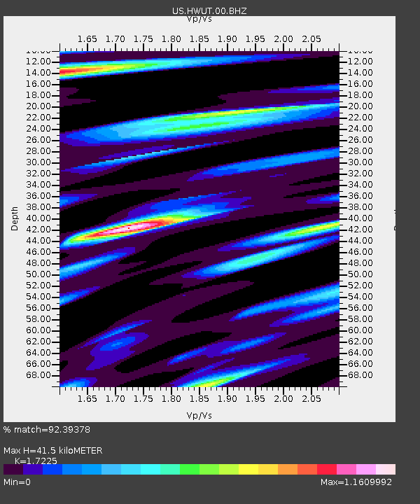
| Estimated Moho Depth: |
41.5 km |
| Estimated Crust Vp/Vs: |
1.72 |
| Assumed Crust Vp: |
6.155 km/s |
| Estimated Crust Vs: |
3.573 km/s |
| Estimated Crust Poisson's Ratio: |
0.25 |
|
| Radial Match: |
92.39378 % |
| Radial Bump: |
331 |
| Transverse Match: |
70.42027 % |
| Transverse Bump: |
400 |
| SOD ConfigId: |
25131211 |
| Insert Time: |
2021-08-12 06:39:55.382 +0000 |
| GWidth: |
2.5 |
| Max Bumps: |
400 |
| Tol: |
0.001 |
|

Signal To Noise
| Channel | StoN | STA | LTA |
| US:HWUT:00:BHZ:20210729T06:21:50.17499Z | 8.272479 | 2.854029E-6 | 3.4500286E-7 |
| US:HWUT:00:BH1:20210729T06:21:50.17499Z | 5.1762714 | 1.1339345E-6 | 2.1906396E-7 |
| US:HWUT:00:BH2:20210729T06:21:50.17499Z | 5.9642963 | 1.5960333E-6 | 2.675979E-7 |
| Arrivals |
| Ps | 5.2 SECOND |
| PpPs | 17 SECOND |
| PsPs/PpSs | 22 SECOND |


