You are here: Home > Network List > US - United States National Seismic Network Stations List
> Station LONY Lake Ozonia, New York, USA > Earthquake Result Viewer
LONY Lake Ozonia, New York, USA - Earthquake Result Viewer
| Earthquake location: |
Alaska Peninsula |
| Earthquake latitude/longitude: |
55.3/-157.8 |
| Earthquake time(UTC): |
2021/07/29 (210) 06:15:45 GMT |
| Earthquake Depth: |
5.2 km |
| Earthquake Magnitude: |
7.3 ml |
| Earthquake Catalog/Contributor: |
NEIC PDE/ak |
|
| Network: |
US United States National Seismic Network |
| Station: |
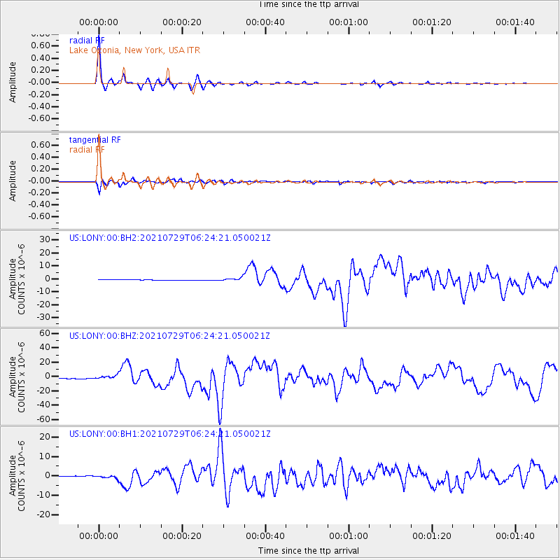
LONY Lake Ozonia, New York, USA |
| Lat/Lon: |
44.62 N/74.58 W |
| Elevation: |
440 m |
|
| Distance: |
51.5 deg |
| Az: |
64.957 deg |
| Baz: |
313.501 deg |
| Ray Param: |
0.06737881 |
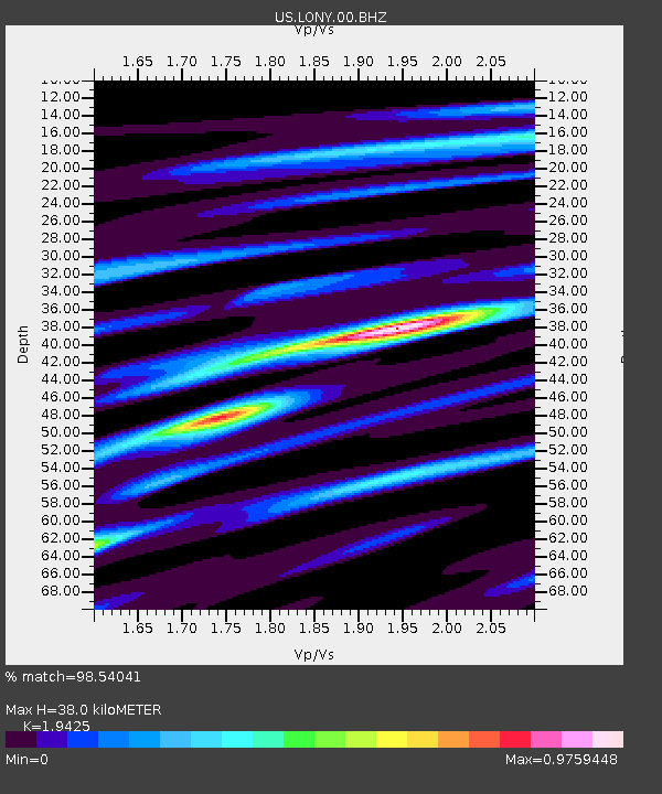
| Estimated Moho Depth: |
38.0 km |
| Estimated Crust Vp/Vs: |
1.94 |
| Assumed Crust Vp: |
6.419 km/s |
| Estimated Crust Vs: |
3.305 km/s |
| Estimated Crust Poisson's Ratio: |
0.32 |
|
| Radial Match: |
98.54041 % |
| Radial Bump: |
218 |
| Transverse Match: |
93.796074 % |
| Transverse Bump: |
400 |
| SOD ConfigId: |
25131211 |
| Insert Time: |
2021-08-12 06:40:05.729 +0000 |
| GWidth: |
2.5 |
| Max Bumps: |
400 |
| Tol: |
0.001 |
|
Signal To Noise
| Channel | StoN | STA | LTA |
| US:LONY:00:BHZ:20210729T06:24:21.050021Z | 8.225533 | 3.1372474E-6 | 3.814036E-7 |
| US:LONY:00:BH1:20210729T06:24:21.050021Z | 6.2283025 | 8.2912163E-7 | 1.331216E-7 |
| US:LONY:00:BH2:20210729T06:24:21.050021Z | 5.9038243 | 1.4894944E-6 | 2.5229315E-7 |
| Arrivals |
| Ps | 5.9 SECOND |
| PpPs | 17 SECOND |
| PsPs/PpSs | 22 SECOND |


