You are here: Home > Network List > US - United States National Seismic Network Stations List
> Station PKME Peaks-Kenny State Park, Maine, USA > Earthquake Result Viewer
PKME Peaks-Kenny State Park, Maine, USA - Earthquake Result Viewer

| Earthquake location: |
Alaska Peninsula |
| Earthquake latitude/longitude: |
55.3/-157.8 |
| Earthquake time(UTC): |
2021/07/29 (210) 06:15:45 GMT |
| Earthquake Depth: |
5.2 km |
| Earthquake Magnitude: |
7.3 ml |
| Earthquake Catalog/Contributor: |
NEIC PDE/ak |
|
| Network: |
US United States National Seismic Network |
| Station: |
PKME Peaks-Kenny State Park, Maine, USA |
| Lat/Lon: |
45.26 N/69.29 W |
| Elevation: |
108 m |
|
| Distance: |
53.8 deg |
| Az: |
61.081 deg |
| Baz: |
314.874 deg |
| Ray Param: |
0.0659036 |
| Estimated Moho Depth: |
33.25 km |
| Estimated Crust Vp/Vs: |
1.75 |
| Assumed Crust Vp: |
6.419 km/s |
| Estimated Crust Vs: |
3.668 km/s |
| Estimated Crust Poisson's Ratio: |
0.26 |
|
| Radial Match: |
96.783714 % |
| Radial Bump: |
296 |
| Transverse Match: |
89.803894 % |
| Transverse Bump: |
400 |
| SOD ConfigId: |
25131211 |
| Insert Time: |
2021-08-12 06:40:19.131 +0000 |
| GWidth: |
2.5 |
| Max Bumps: |
400 |
| Tol: |
0.001 |
|
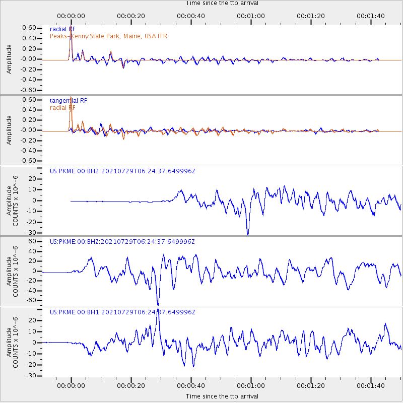
Signal To Noise
| Channel | StoN | STA | LTA |
| US:PKME:00:BHZ:20210729T06:24:37.649996Z | 9.581159 | 4.0766295E-6 | 4.2548402E-7 |
| US:PKME:00:BH1:20210729T06:24:37.649996Z | 5.798172 | 1.50905E-6 | 2.6026308E-7 |
| US:PKME:00:BH2:20210729T06:24:37.649996Z | 5.8512783 | 1.3587587E-6 | 2.322157E-7 |
| Arrivals |
| Ps | 4.1 SECOND |
| PpPs | 13 SECOND |
| PsPs/PpSs | 18 SECOND |


