You are here: Home > Network List > UU - University of Utah Regional Network Stations List
> Station TCRU Three Creek Reservoir, UT, USA > Earthquake Result Viewer
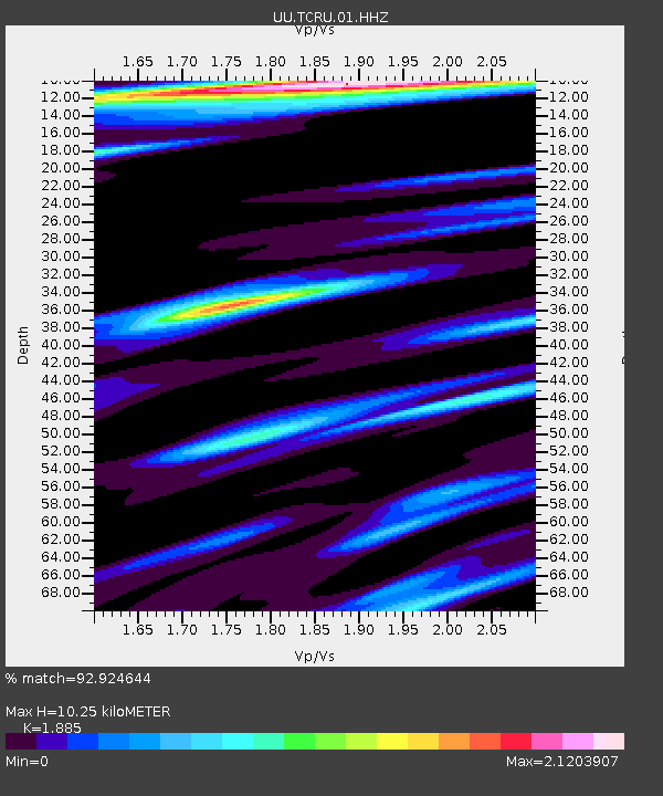
TCRU Three Creek Reservoir, UT, USA - Earthquake Result Viewer
| Earthquake location: |
Alaska Peninsula |
| Earthquake latitude/longitude: |
55.3/-157.8 |
| Earthquake time(UTC): |
2021/07/29 (210) 06:15:45 GMT |
| Earthquake Depth: |
5.2 km |
| Earthquake Magnitude: |
7.3 ml |
| Earthquake Catalog/Contributor: |
NEIC PDE/ak |
|
| Network: |
UU University of Utah Regional Network |
| Station: |
TCRU Three Creek Reservoir, UT, USA |
| Lat/Lon: |
38.61 N/112.45 W |
| Elevation: |
2293 m |
|
| Distance: |
34.5 deg |
| Az: |
99.78 deg |
| Baz: |
314.013 deg |
| Ray Param: |
0.07774347 |
| Estimated Moho Depth: |
10.25 km |
| Estimated Crust Vp/Vs: |
1.88 |
| Assumed Crust Vp: |
6.276 km/s |
| Estimated Crust Vs: |
3.329 km/s |
| Estimated Crust Poisson's Ratio: |
0.30 |
|
| Radial Match: |
92.924644 % |
| Radial Bump: |
360 |
| Transverse Match: |
92.87288 % |
| Transverse Bump: |
374 |
| SOD ConfigId: |
25131211 |
| Insert Time: |
2021-08-12 06:41:10.377 +0000 |
| GWidth: |
2.5 |
| Max Bumps: |
400 |
| Tol: |
0.001 |
|

Signal To Noise
| Channel | StoN | STA | LTA |
| UU:TCRU:01:HHZ:20210729T06:22:03.329989Z | 5.7779837 | 9.80366E-8 | 1.6967268E-8 |
| UU:TCRU:01:HHN:20210729T06:22:03.329989Z | 4.4411225 | 5.4673343E-8 | 1.2310704E-8 |
| UU:TCRU:01:HHE:20210729T06:22:03.329989Z | 6.090786 | 6.170392E-8 | 1.01307E-8 |
| Arrivals |
| Ps | 1.5 SECOND |
| PpPs | 4.4 SECOND |
| PsPs/PpSs | 5.9 SECOND |


