You are here: Home > Network List > WI - West Indies IPGP Network Stations List
> Station BIM Morne Bigot, Anses d'Arlets, Martinique > Earthquake Result Viewer
BIM Morne Bigot, Anses d'Arlets, Martinique - Earthquake Result Viewer
| Earthquake location: |
Alaska Peninsula |
| Earthquake latitude/longitude: |
55.3/-157.8 |
| Earthquake time(UTC): |
2021/07/29 (210) 06:15:45 GMT |
| Earthquake Depth: |
5.2 km |
| Earthquake Magnitude: |
7.3 ml |
| Earthquake Catalog/Contributor: |
NEIC PDE/ak |
|
| Network: |
WI West Indies IPGP Network |
| Station: |
BIM Morne Bigot, Anses d'Arlets, Martinique |
| Lat/Lon: |
14.52 N/61.07 W |
| Elevation: |
391 m |
|
| Distance: |
82.0 deg |
| Az: |
76.211 deg |
| Baz: |
325.015 deg |
| Ray Param: |
0.04720111 |
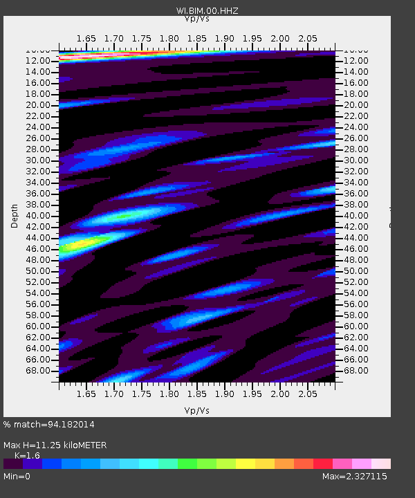
| Estimated Moho Depth: |
11.25 km |
| Estimated Crust Vp/Vs: |
1.60 |
| Assumed Crust Vp: |
5.88 km/s |
| Estimated Crust Vs: |
3.675 km/s |
| Estimated Crust Poisson's Ratio: |
0.18 |
|
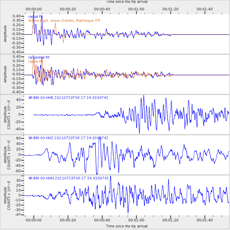
| Radial Match: |
94.182014 % |
| Radial Bump: |
400 |
| Transverse Match: |
84.760216 % |
| Transverse Bump: |
400 |
| SOD ConfigId: |
25131211 |
| Insert Time: |
2021-08-12 06:41:27.252 +0000 |
| GWidth: |
2.5 |
| Max Bumps: |
400 |
| Tol: |
0.001 |
|
Signal To Noise
| Channel | StoN | STA | LTA |
| WI:BIM:00:HHZ:20210729T06:27:34.939974Z | 3.148001 | 1.4148163E-6 | 4.4943326E-7 |
| WI:BIM:00:HHN:20210729T06:27:34.939974Z | 1.8147974 | 9.346122E-7 | 5.1499535E-7 |
| WI:BIM:00:HHE:20210729T06:27:34.939974Z | 0.8571352 | 6.175088E-7 | 7.2043343E-7 |
| Arrivals |
| Ps | 1.2 SECOND |
| PpPs | 4.9 SECOND |
| PsPs/PpSs | 6.0 SECOND |


