You are here: Home > Network List > CA - Catalan Seismic Network Stations List
> Station CFON Fontmartina > Earthquake Result Viewer
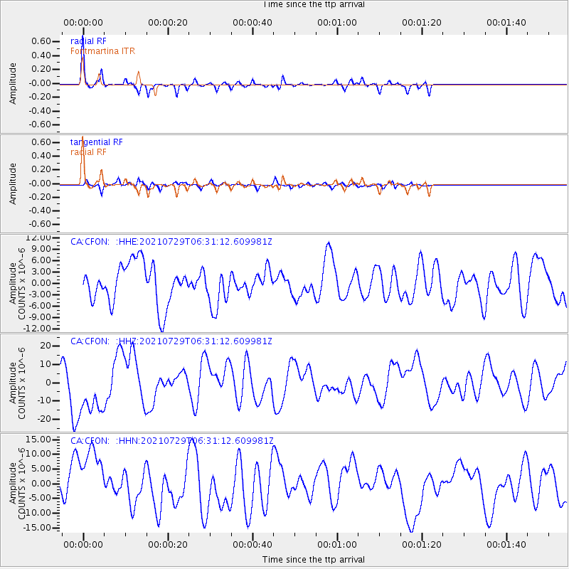
CFON Fontmartina - Earthquake Result Viewer

| Earthquake location: |
Alaska Peninsula |
| Earthquake latitude/longitude: |
55.1/-158.1 |
| Earthquake time(UTC): |
2021/07/29 (210) 06:19:25 GMT |
| Earthquake Depth: |
27 km |
| Earthquake Magnitude: |
6.1 mb |
| Earthquake Catalog/Contributor: |
NEIC PDE/us |
|
| Network: |
CA Catalan Seismic Network |
| Station: |
CFON Fontmartina |
| Lat/Lon: |
41.76 N/2.43 E |
| Elevation: |
973 m |
|
| Distance: |
82.1 deg |
| Az: |
14.552 deg |
| Baz: |
348.86 deg |
| Ray Param: |
0.047070116 |
| Estimated Moho Depth: |
41.5 km |
| Estimated Crust Vp/Vs: |
1.61 |
| Assumed Crust Vp: |
5.88 km/s |
| Estimated Crust Vs: |
3.664 km/s |
| Estimated Crust Poisson's Ratio: |
0.18 |
|
| Radial Match: |
84.2021 % |
| Radial Bump: |
251 |
| Transverse Match: |
57.09943 % |
| Transverse Bump: |
342 |
| SOD ConfigId: |
25131211 |
| Insert Time: |
2021-08-12 06:44:00.090 +0000 |
| GWidth: |
2.5 |
| Max Bumps: |
400 |
| Tol: |
0.001 |
|
Signal To Noise
| Channel | StoN | STA | LTA |
| CA:CFON: :HHZ:20210729T06:31:12.609981Z | 0.9941977 | 1.51594195E-5 | 1.52478915E-5 |
| CA:CFON: :HHN:20210729T06:31:12.609981Z | 1.2532462 | 1.0789174E-5 | 8.608982E-6 |
| CA:CFON: :HHE:20210729T06:31:12.609981Z | 1.0023137 | 5.2591445E-6 | 5.2470045E-6 |
| Arrivals |
| Ps | 4.4 SECOND |
| PpPs | 18 SECOND |
| PsPs/PpSs | 22 SECOND |


