You are here: Home > Network List > CA - Catalan Seismic Network Stations List
> Station CGAR Garraf > Earthquake Result Viewer
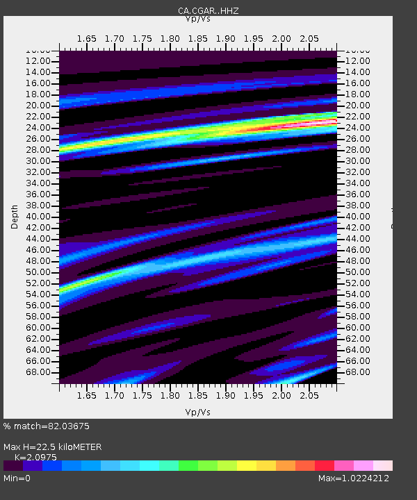
CGAR Garraf - Earthquake Result Viewer
| Earthquake location: |
Alaska Peninsula |
| Earthquake latitude/longitude: |
55.1/-158.1 |
| Earthquake time(UTC): |
2021/07/29 (210) 06:19:25 GMT |
| Earthquake Depth: |
27 km |
| Earthquake Magnitude: |
6.1 mb |
| Earthquake Catalog/Contributor: |
NEIC PDE/us |
|
| Network: |
CA Catalan Seismic Network |
| Station: |
CGAR Garraf |
| Lat/Lon: |
41.29 N/1.91 E |
| Elevation: |
584 m |
|
| Distance: |
82.5 deg |
| Az: |
15.031 deg |
| Baz: |
348.58 deg |
| Ray Param: |
0.046804275 |
| Estimated Moho Depth: |
22.5 km |
| Estimated Crust Vp/Vs: |
2.10 |
| Assumed Crust Vp: |
6.391 km/s |
| Estimated Crust Vs: |
3.047 km/s |
| Estimated Crust Poisson's Ratio: |
0.35 |
|
| Radial Match: |
82.03675 % |
| Radial Bump: |
341 |
| Transverse Match: |
65.18209 % |
| Transverse Bump: |
400 |
| SOD ConfigId: |
25131211 |
| Insert Time: |
2021-08-12 06:44:01.770 +0000 |
| GWidth: |
2.5 |
| Max Bumps: |
400 |
| Tol: |
0.001 |
|

Signal To Noise
| Channel | StoN | STA | LTA |
| CA:CGAR: :HHZ:20210729T06:31:14.599972Z | 1.0217444 | 2.0761356E-5 | 2.031952E-5 |
| CA:CGAR: :HHN:20210729T06:31:14.599972Z | 1.2573667 | 1.3121273E-5 | 1.0435518E-5 |
| CA:CGAR: :HHE:20210729T06:31:14.599972Z | 1.3423736 | 6.353104E-6 | 4.732739E-6 |
| Arrivals |
| Ps | 3.9 SECOND |
| PpPs | 11 SECOND |
| PsPs/PpSs | 15 SECOND |


