You are here: Home > Network List > GS - US Geological Survey Networks Stations List
> Station ASL8 Albuquerque, New Mexico, USA > Earthquake Result Viewer
ASL8 Albuquerque, New Mexico, USA - Earthquake Result Viewer
| Earthquake location: |
Alaska Peninsula |
| Earthquake latitude/longitude: |
55.1/-158.1 |
| Earthquake time(UTC): |
2021/07/29 (210) 06:19:25 GMT |
| Earthquake Depth: |
27 km |
| Earthquake Magnitude: |
6.1 mb |
| Earthquake Catalog/Contributor: |
NEIC PDE/us |
|
| Network: |
GS US Geological Survey Networks |
| Station: |
ASL8 Albuquerque, New Mexico, USA |
| Lat/Lon: |
34.95 N/106.46 W |
| Elevation: |
1820 m |
|
| Distance: |
40.6 deg |
| Az: |
97.831 deg |
| Baz: |
316.072 deg |
| Ray Param: |
0.07427065 |
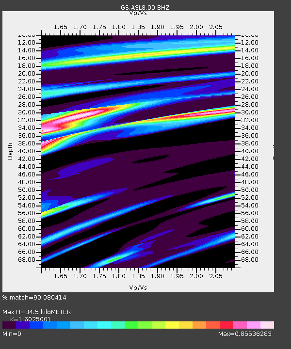
| Estimated Moho Depth: |
34.5 km |
| Estimated Crust Vp/Vs: |
1.60 |
| Assumed Crust Vp: |
6.502 km/s |
| Estimated Crust Vs: |
4.057 km/s |
| Estimated Crust Poisson's Ratio: |
0.18 |
|
| Radial Match: |
90.080414 % |
| Radial Bump: |
400 |
| Transverse Match: |
57.201942 % |
| Transverse Bump: |
400 |
| SOD ConfigId: |
25131211 |
| Insert Time: |
2021-08-12 06:47:05.090 +0000 |
| GWidth: |
2.5 |
| Max Bumps: |
400 |
| Tol: |
0.001 |
|
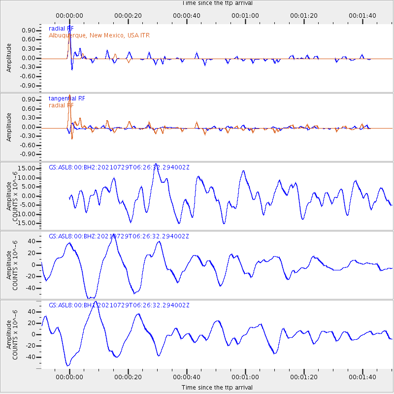
Signal To Noise
| Channel | StoN | STA | LTA |
| GS:ASL8:00:BHZ:20210729T06:26:32.294002Z | 2.3692272 | 2.9070186E-5 | 1.2269902E-5 |
| GS:ASL8:00:BH1:20210729T06:26:32.294002Z | 3.0728629 | 3.940424E-5 | 1.2823299E-5 |
| GS:ASL8:00:BH2:20210729T06:26:32.294002Z | 2.1918643 | 1.1658987E-5 | 5.3192102E-6 |
| Arrivals |
| Ps | 3.5 SECOND |
| PpPs | 13 SECOND |
| PsPs/PpSs | 16 SECOND |


