You are here: Home > Network List > GS - US Geological Survey Networks Stations List
> Station DEC08 Union Local 159 Surface Site > Earthquake Result Viewer
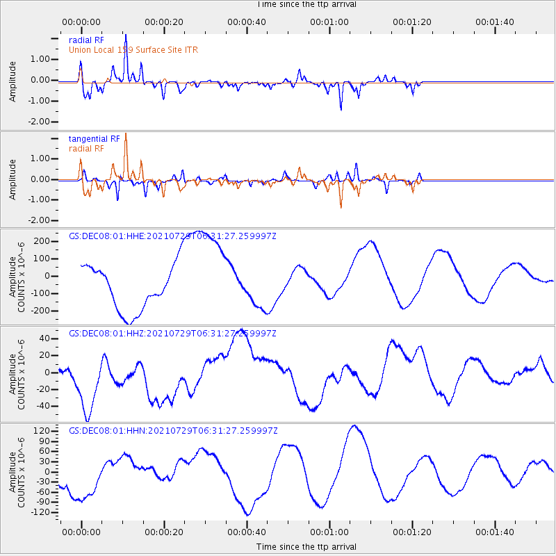
DEC08 Union Local 159 Surface Site - Earthquake Result Viewer
*The percent match for this event was below the threshold and hence no stack was calculated.
| Earthquake location: |
Alaska Peninsula |
| Earthquake latitude/longitude: |
55.4/-157.3 |
| Earthquake time(UTC): |
2021/07/29 (210) 06:23:28 GMT |
| Earthquake Depth: |
5.3 km |
| Earthquake Magnitude: |
5.9 ml |
| Earthquake Catalog/Contributor: |
NEIC PDE/ak |
|
| Network: |
GS US Geological Survey Networks |
| Station: |
DEC08 Union Local 159 Surface Site |
| Lat/Lon: |
39.86 N/88.92 W |
| Elevation: |
210 m |
|
| Distance: |
46.7 deg |
| Az: |
79.591 deg |
| Baz: |
313.218 deg |
| Ray Param: |
$rayparam |
*The percent match for this event was below the threshold and hence was not used in the summary stack. |
|
| Radial Match: |
49.427326 % |
| Radial Bump: |
242 |
| Transverse Match: |
47.57928 % |
| Transverse Bump: |
204 |
| SOD ConfigId: |
25131211 |
| Insert Time: |
2021-08-12 07:00:54.394 +0000 |
| GWidth: |
2.5 |
| Max Bumps: |
400 |
| Tol: |
0.001 |
|
Signal To Noise
| Channel | StoN | STA | LTA |
| GS:DEC08:01:HHZ:20210729T06:31:27.259997Z | 1.3125627 | 4.415372E-5 | 3.3639324E-5 |
| GS:DEC08:01:HHN:20210729T06:31:27.259997Z | 1.9806693 | 7.414248E-5 | 3.7433045E-5 |
| GS:DEC08:01:HHE:20210729T06:31:27.259997Z | 2.1508183 | 2.7957984E-4 | 1.2998766E-4 |
| Arrivals |
| Ps | |
| PpPs | |
| PsPs/PpSs | |


