You are here: Home > Network List > WY - Yellowstone Wyoming Seismic Network Stations List
> Station YHH Holmes Hill, YNP, WY, USA > Earthquake Result Viewer
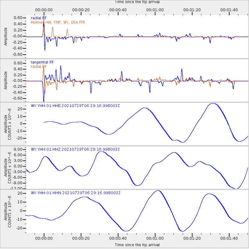
YHH Holmes Hill, YNP, WY, USA - Earthquake Result Viewer
*The percent match for this event was below the threshold and hence no stack was calculated.
| Earthquake location: |
Alaska Peninsula |
| Earthquake latitude/longitude: |
55.4/-157.3 |
| Earthquake time(UTC): |
2021/07/29 (210) 06:23:28 GMT |
| Earthquake Depth: |
5.3 km |
| Earthquake Magnitude: |
5.9 ml |
| Earthquake Catalog/Contributor: |
NEIC PDE/ak |
|
| Network: |
WY Yellowstone Wyoming Seismic Network |
| Station: |
YHH Holmes Hill, YNP, WY, USA |
| Lat/Lon: |
44.79 N/110.85 W |
| Elevation: |
2717 m |
|
| Distance: |
31.1 deg |
| Az: |
90.254 deg |
| Baz: |
306.783 deg |
| Ray Param: |
$rayparam |
*The percent match for this event was below the threshold and hence was not used in the summary stack. |
|
| Radial Match: |
60.80161 % |
| Radial Bump: |
313 |
| Transverse Match: |
38.736923 % |
| Transverse Bump: |
177 |
| SOD ConfigId: |
25131211 |
| Insert Time: |
2021-08-12 07:13:47.181 +0000 |
| GWidth: |
2.5 |
| Max Bumps: |
400 |
| Tol: |
0.001 |
|
Signal To Noise
| Channel | StoN | STA | LTA |
| WY:YHH:01:HHZ:20210729T06:29:16.998003Z | 3.439846 | 4.8009447E-6 | 1.395686E-6 |
| WY:YHH:01:HHN:20210729T06:29:16.998003Z | 2.623777 | 9.8691235E-6 | 3.7614188E-6 |
| WY:YHH:01:HHE:20210729T06:29:16.998003Z | 9.147649 | 1.2910508E-5 | 1.4113472E-6 |
| Arrivals |
| Ps | |
| PpPs | |
| PsPs/PpSs | |


