You are here: Home > Network List > XG95 - Nanga Parbat Pakistan Stations List
> Station DMB02 Chilas > Earthquake Result Viewer
DMB02 Chilas - Earthquake Result Viewer
| Earthquake location: |
Taiwan Region |
| Earthquake latitude/longitude: |
21.9/121.5 |
| Earthquake time(UTC): |
1996/09/05 (249) 23:42:06 GMT |
| Earthquake Depth: |
20 km |
| Earthquake Magnitude: |
6.4 MB, 6.6 MS, 6.8 UNKNOWN, 6.8 ME |
| Earthquake Catalog/Contributor: |
WHDF/NEIC |
|
| Network: |
XG Nanga Parbat Pakistan |
| Station: |
DMB02 Chilas |
| Lat/Lon: |
35.41 N/74.11 E |
| Elevation: |
1155 m |
|
| Distance: |
43.3 deg |
| Az: |
298.808 deg |
| Baz: |
94.997 deg |
| Ray Param: |
0.07259899 |
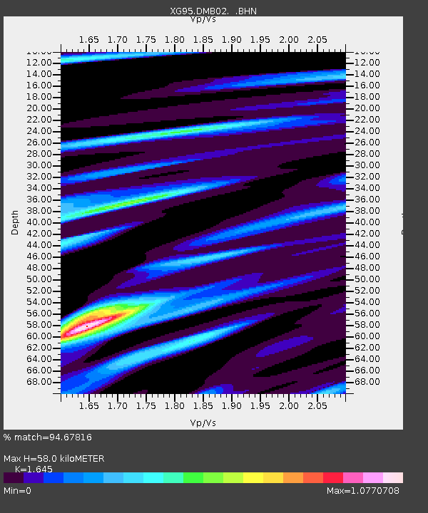
| Estimated Moho Depth: |
58.0 km |
| Estimated Crust Vp/Vs: |
1.64 |
| Assumed Crust Vp: |
6.481 km/s |
| Estimated Crust Vs: |
3.94 km/s |
| Estimated Crust Poisson's Ratio: |
0.21 |
|
| Radial Match: |
94.67816 % |
| Radial Bump: |
353 |
| Transverse Match: |
92.41705 % |
| Transverse Bump: |
400 |
| SOD ConfigId: |
6273 |
| Insert Time: |
2010-03-09 11:03:02.282 +0000 |
| GWidth: |
2.5 |
| Max Bumps: |
400 |
| Tol: |
0.001 |
|

Signal To Noise
| Channel | StoN | STA | LTA |
| XG:DMB02: :BHN:19960905T23:49:35.81701Z | 4.863151 | 1.9960211E-7 | 4.104378E-8 |
| XG:DMB02: :BHE:19960905T23:49:35.81701Z | 36.529747 | 1.0145365E-6 | 2.7772884E-8 |
| XG:DMB02: :BHZ:19960905T23:49:35.81701Z | 61.365376 | 1.9355675E-6 | 3.1541685E-8 |
| Arrivals |
| Ps | 6.2 SECOND |
| PpPs | 22 SECOND |
| PsPs/PpSs | 28 SECOND |


