You are here: Home > Network List > GS - US Geological Survey Networks Stations List
> Station DEC06 Boomer > Earthquake Result Viewer
DEC06 Boomer - Earthquake Result Viewer
| Earthquake location: |
South Of Alaska |
| Earthquake latitude/longitude: |
54.9/-156.4 |
| Earthquake time(UTC): |
2021/07/29 (210) 06:32:30 GMT |
| Earthquake Depth: |
10 km |
| Earthquake Magnitude: |
5.8 mb |
| Earthquake Catalog/Contributor: |
NEIC PDE/ak |
|
| Network: |
GS US Geological Survey Networks |
| Station: |
DEC06 Boomer |
| Lat/Lon: |
39.90 N/88.95 W |
| Elevation: |
215 m |
|
| Distance: |
46.2 deg |
| Az: |
79.783 deg |
| Baz: |
312.397 deg |
| Ray Param: |
0.07079494 |
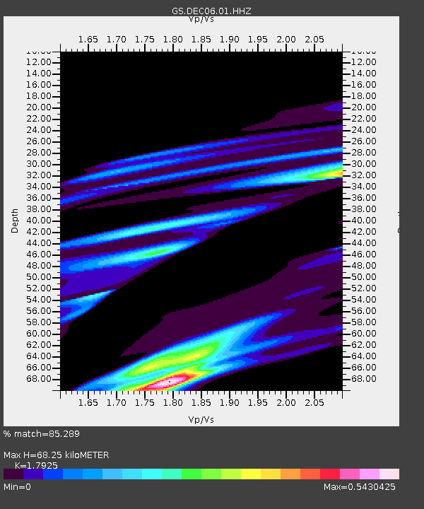
| Estimated Moho Depth: |
68.25 km |
| Estimated Crust Vp/Vs: |
1.79 |
| Assumed Crust Vp: |
6.444 km/s |
| Estimated Crust Vs: |
3.595 km/s |
| Estimated Crust Poisson's Ratio: |
0.27 |
|
| Radial Match: |
85.289 % |
| Radial Bump: |
400 |
| Transverse Match: |
25.740784 % |
| Transverse Bump: |
171 |
| SOD ConfigId: |
25131211 |
| Insert Time: |
2021-08-12 07:19:16.082 +0000 |
| GWidth: |
2.5 |
| Max Bumps: |
400 |
| Tol: |
0.001 |
|

Signal To Noise
| Channel | StoN | STA | LTA |
| GS:DEC06:01:HHZ:20210729T06:40:24.660013Z | 1.8089497 | 3.5158996E-4 | 1.9436138E-4 |
| GS:DEC06:01:HHN:20210729T06:40:24.660013Z | 0.57839036 | 2.0805057E-4 | 3.5970614E-4 |
| GS:DEC06:01:HHE:20210729T06:40:24.660013Z | 1.7975701 | 4.391248E-4 | 2.44288E-4 |
| Arrivals |
| Ps | 8.9 SECOND |
| PpPs | 28 SECOND |
| PsPs/PpSs | 37 SECOND |


