You are here: Home > Network List > GS - US Geological Survey Networks Stations List
> Station DEC08 Union Local 159 Surface Site > Earthquake Result Viewer
DEC08 Union Local 159 Surface Site - Earthquake Result Viewer
| Earthquake location: |
South Of Alaska |
| Earthquake latitude/longitude: |
54.9/-156.4 |
| Earthquake time(UTC): |
2021/07/29 (210) 06:32:30 GMT |
| Earthquake Depth: |
10 km |
| Earthquake Magnitude: |
5.8 mb |
| Earthquake Catalog/Contributor: |
NEIC PDE/ak |
|
| Network: |
GS US Geological Survey Networks |
| Station: |
DEC08 Union Local 159 Surface Site |
| Lat/Lon: |
39.86 N/88.92 W |
| Elevation: |
210 m |
|
| Distance: |
46.3 deg |
| Az: |
79.804 deg |
| Baz: |
312.425 deg |
| Ray Param: |
0.07077174 |
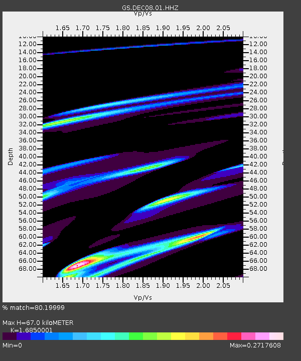
| Estimated Moho Depth: |
67.0 km |
| Estimated Crust Vp/Vs: |
1.69 |
| Assumed Crust Vp: |
6.444 km/s |
| Estimated Crust Vs: |
3.824 km/s |
| Estimated Crust Poisson's Ratio: |
0.23 |
|
| Radial Match: |
80.19999 % |
| Radial Bump: |
400 |
| Transverse Match: |
24.715403 % |
| Transverse Bump: |
197 |
| SOD ConfigId: |
25131211 |
| Insert Time: |
2021-08-12 07:19:16.250 +0000 |
| GWidth: |
2.5 |
| Max Bumps: |
400 |
| Tol: |
0.001 |
|
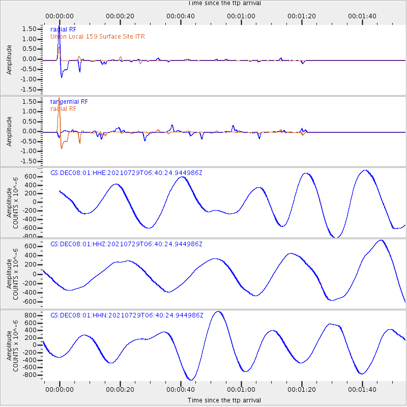
Signal To Noise
| Channel | StoN | STA | LTA |
| GS:DEC08:01:HHZ:20210729T06:40:24.944986Z | 1.7133646 | 3.4166256E-4 | 1.994103E-4 |
| GS:DEC08:01:HHN:20210729T06:40:24.944986Z | 0.66332155 | 2.571436E-4 | 3.8766055E-4 |
| GS:DEC08:01:HHE:20210729T06:40:24.944986Z | 2.2415848 | 5.0292944E-4 | 2.2436332E-4 |
| Arrivals |
| Ps | 7.6 SECOND |
| PpPs | 26 SECOND |
| PsPs/PpSs | 34 SECOND |


