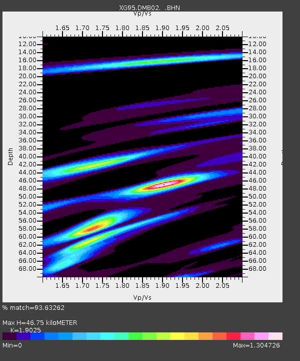
DMB02 Chilas - Earthquake Result Viewer

Earthquake location: Andreanof Islands, Aleutian Is.
Earthquake latitude/longitude: 51.6/-177.6
Earthquake time(UTC): 1996/06/10 (162) 04:03:35 GMT
Earthquake Depth: 33 km
Earthquake Magnitude: 6.6 MB, 7.6 MS, 7.9 UNKNOWN, 7.4 MS
Earthquake Catalog/Contributor: WHDF/NEIC
Network: XG Nanga Parbat Pakistan
Station: DMB02 Chilas
Lat/Lon: 35.41 N/74.11 E
Elevation: 1155 m
Distance: 73.1 deg
Az: 305.825 deg
Baz: 38.284 deg
Ray Param: 0.05318514
Estimated Moho Depth: 46.75 km
Estimated Crust Vp/Vs: 1.90
Assumed Crust Vp: 6.481 km/s
Estimated Crust Vs: 3.406 km/s
Estimated Crust Poisson's Ratio: 0.31
Radial Match: 93.63262 %
Radial Bump: 400
Transverse Match: 89.45362 %
Transverse Bump: 400
SOD ConfigId: 6273
Insert Time: 2010-03-09 11:03:07.806 +0000
GWidth: 2.5
Max Bumps: 400
Tol: 0.001

Signal To Noise

ChannelStoNSTALTA
XG:DMB02: :BHN:19960610T04:14:31.355017Z33.6342051.1910091E-63.541065E-8
XG:DMB02: :BHE:19960610T04:14:31.355017Z16.033977.1133564E-74.4364285E-8
XG:DMB02: :BHZ:19960610T04:14:31.355017Z30.600992.9063128E-69.4974475E-8
Arrivals
Ps6.7 SECOND
PpPs20 SECOND
PsPs/PpSs27 SECOND