You are here: Home > Network List > N4 - Central and EAstern US Network Stations List
> Station 441B Storozyszyn Site, DeRidder, LA, USA > Earthquake Result Viewer
441B Storozyszyn Site, DeRidder, LA, USA - Earthquake Result Viewer
| Earthquake location: |
South Of Alaska |
| Earthquake latitude/longitude: |
54.9/-156.4 |
| Earthquake time(UTC): |
2021/07/29 (210) 06:32:30 GMT |
| Earthquake Depth: |
10 km |
| Earthquake Magnitude: |
5.8 mb |
| Earthquake Catalog/Contributor: |
NEIC PDE/ak |
|
| Network: |
N4 Central and EAstern US Network |
| Station: |
441B Storozyszyn Site, DeRidder, LA, USA |
| Lat/Lon: |
30.75 N/93.19 W |
| Elevation: |
33 m |
|
| Distance: |
50.3 deg |
| Az: |
91.715 deg |
| Baz: |
317.913 deg |
| Ray Param: |
0.06817814 |
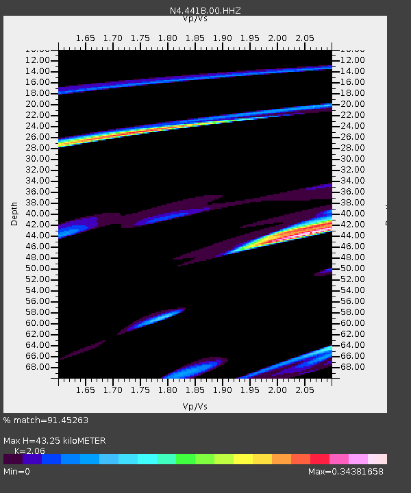
| Estimated Moho Depth: |
43.25 km |
| Estimated Crust Vp/Vs: |
2.06 |
| Assumed Crust Vp: |
6.065 km/s |
| Estimated Crust Vs: |
2.944 km/s |
| Estimated Crust Poisson's Ratio: |
0.35 |
|
| Radial Match: |
91.45263 % |
| Radial Bump: |
339 |
| Transverse Match: |
68.968346 % |
| Transverse Bump: |
400 |
| SOD ConfigId: |
25131211 |
| Insert Time: |
2021-08-12 07:21:50.063 +0000 |
| GWidth: |
2.5 |
| Max Bumps: |
400 |
| Tol: |
0.001 |
|

Signal To Noise
| Channel | StoN | STA | LTA |
| N4:441B:00:HHZ:20210729T06:40:55.780008Z | 1.6332531 | 1.8081165E-4 | 1.10706445E-4 |
| N4:441B:00:HH1:20210729T06:40:55.780008Z | 1.595288 | 4.000602E-4 | 2.5077615E-4 |
| N4:441B:00:HH2:20210729T06:40:55.780008Z | 1.2956666 | 6.1861076E-4 | 4.7744592E-4 |
| Arrivals |
| Ps | 7.9 SECOND |
| PpPs | 21 SECOND |
| PsPs/PpSs | 29 SECOND |


