You are here: Home > Network List > NE - New England Seismic Network Stations List
> Station EMMW Machias, ME, USA > Earthquake Result Viewer
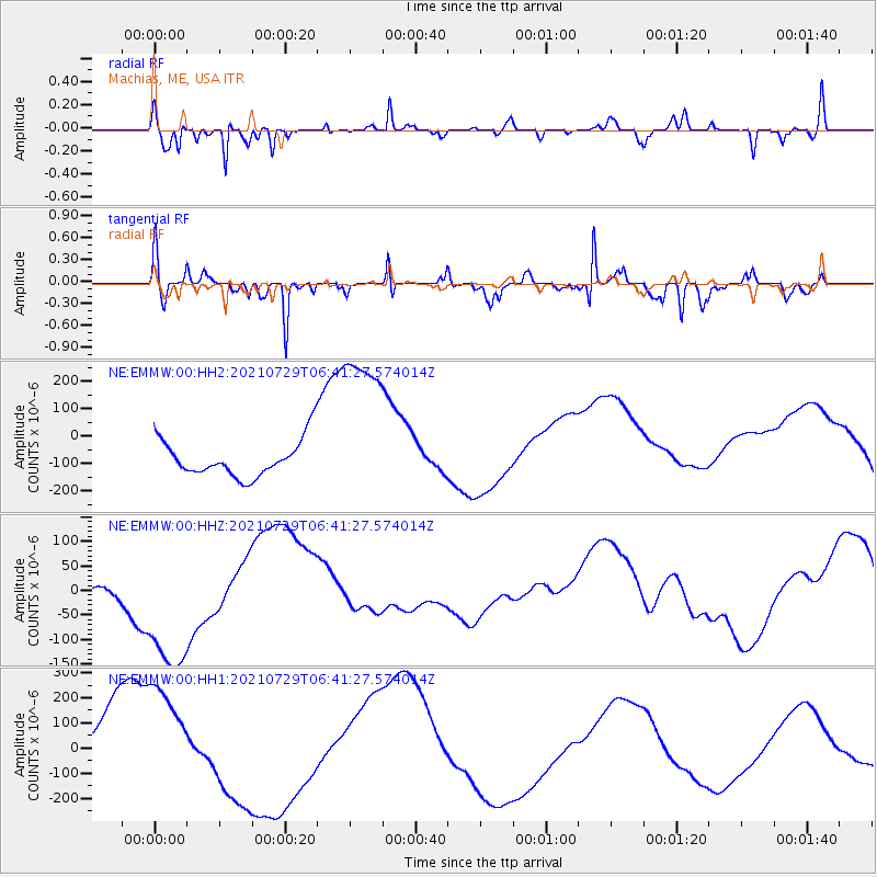
EMMW Machias, ME, USA - Earthquake Result Viewer
*The percent match for this event was below the threshold and hence no stack was calculated.
| Earthquake location: |
South Of Alaska |
| Earthquake latitude/longitude: |
54.9/-156.4 |
| Earthquake time(UTC): |
2021/07/29 (210) 06:32:30 GMT |
| Earthquake Depth: |
10 km |
| Earthquake Magnitude: |
5.8 mb |
| Earthquake Catalog/Contributor: |
NEIC PDE/ak |
|
| Network: |
NE New England Seismic Network |
| Station: |
EMMW Machias, ME, USA |
| Lat/Lon: |
44.71 N/67.46 W |
| Elevation: |
35 m |
|
| Distance: |
54.6 deg |
| Az: |
61.067 deg |
| Baz: |
314.884 deg |
| Ray Param: |
$rayparam |
*The percent match for this event was below the threshold and hence was not used in the summary stack. |
|
| Radial Match: |
89.96549 % |
| Radial Bump: |
250 |
| Transverse Match: |
36.605522 % |
| Transverse Bump: |
220 |
| SOD ConfigId: |
25131211 |
| Insert Time: |
2021-08-12 07:23:00.204 +0000 |
| GWidth: |
2.5 |
| Max Bumps: |
400 |
| Tol: |
0.001 |
|
Signal To Noise
| Channel | StoN | STA | LTA |
| NE:EMMW:00:HHZ:20210729T06:41:27.574014Z | 6.2392607 | 1.6545199E-4 | 2.6517884E-5 |
| NE:EMMW:00:HH1:20210729T06:41:27.574014Z | 2.1258042 | 2.4830387E-4 | 1.1680467E-4 |
| NE:EMMW:00:HH2:20210729T06:41:27.574014Z | 4.8355985 | 3.24184E-4 | 6.704113E-5 |
| Arrivals |
| Ps | |
| PpPs | |
| PsPs/PpSs | |


