You are here: Home > Network List > O2 - Oklahoma Consolidated Temporary Seismic Networks Stations List
> Station PW09 Ralston, Oklahoma > Earthquake Result Viewer
PW09 Ralston, Oklahoma - Earthquake Result Viewer
| Earthquake location: |
South Of Alaska |
| Earthquake latitude/longitude: |
54.9/-156.4 |
| Earthquake time(UTC): |
2021/07/29 (210) 06:32:30 GMT |
| Earthquake Depth: |
10 km |
| Earthquake Magnitude: |
5.8 mb |
| Earthquake Catalog/Contributor: |
NEIC PDE/ak |
|
| Network: |
O2 Oklahoma Consolidated Temporary Seismic Networks |
| Station: |
PW09 Ralston, Oklahoma |
| Lat/Lon: |
36.45 N/96.82 W |
| Elevation: |
291 m |
|
| Distance: |
44.1 deg |
| Az: |
89.319 deg |
| Baz: |
314.281 deg |
| Ray Param: |
0.07215819 |
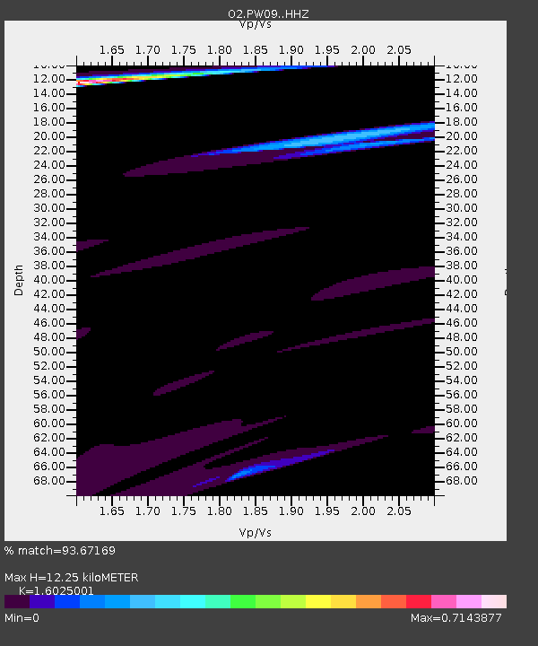
| Estimated Moho Depth: |
12.25 km |
| Estimated Crust Vp/Vs: |
1.60 |
| Assumed Crust Vp: |
6.483 km/s |
| Estimated Crust Vs: |
4.045 km/s |
| Estimated Crust Poisson's Ratio: |
0.18 |
|
| Radial Match: |
93.67169 % |
| Radial Bump: |
400 |
| Transverse Match: |
27.100655 % |
| Transverse Bump: |
400 |
| SOD ConfigId: |
25131211 |
| Insert Time: |
2021-08-12 07:24:04.852 +0000 |
| GWidth: |
2.5 |
| Max Bumps: |
400 |
| Tol: |
0.001 |
|

Signal To Noise
| Channel | StoN | STA | LTA |
| O2:PW09: :HHZ:20210729T06:40:07.535013Z | 1.9438374 | 7.968448E-4 | 4.0993385E-4 |
| O2:PW09: :HHN:20210729T06:40:07.535013Z | 1.4849213 | 2.453803E-4 | 1.6524801E-4 |
| O2:PW09: :HHE:20210729T06:40:07.535013Z | 0.73098993 | 2.949311E-4 | 4.0346806E-4 |
| Arrivals |
| Ps | 1.2 SECOND |
| PpPs | 4.6 SECOND |
| PsPs/PpSs | 5.8 SECOND |


