You are here: Home > Network List > XG95 - Nanga Parbat Pakistan Stations List
> Station DMB02 Chilas > Earthquake Result Viewer
DMB02 Chilas - Earthquake Result Viewer
| Earthquake location: |
Mariana Islands |
| Earthquake latitude/longitude: |
18.7/145.6 |
| Earthquake time(UTC): |
1996/07/15 (197) 16:51:22 GMT |
| Earthquake Depth: |
177 km |
| Earthquake Magnitude: |
5.9 MB, 6.3 UNKNOWN, 6.3 MW |
| Earthquake Catalog/Contributor: |
WHDF/NEIC |
|
| Network: |
XG Nanga Parbat Pakistan |
| Station: |
DMB02 Chilas |
| Lat/Lon: |
35.41 N/74.11 E |
| Elevation: |
1155 m |
|
| Distance: |
64.6 deg |
| Az: |
300.918 deg |
| Baz: |
84.446 deg |
| Ray Param: |
0.058320325 |
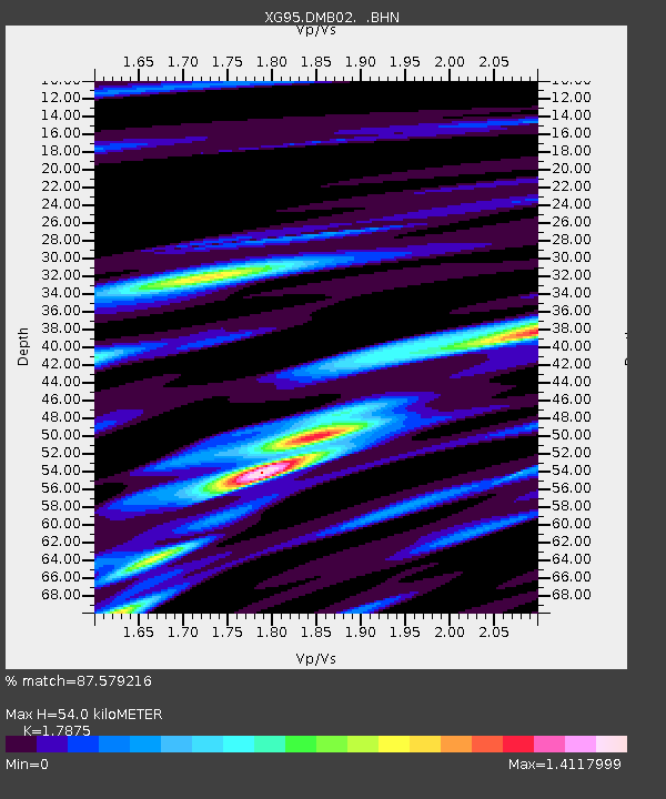
| Estimated Moho Depth: |
54.0 km |
| Estimated Crust Vp/Vs: |
1.79 |
| Assumed Crust Vp: |
6.481 km/s |
| Estimated Crust Vs: |
3.626 km/s |
| Estimated Crust Poisson's Ratio: |
0.27 |
|
| Radial Match: |
87.579216 % |
| Radial Bump: |
400 |
| Transverse Match: |
85.38742 % |
| Transverse Bump: |
400 |
| SOD ConfigId: |
6273 |
| Insert Time: |
2010-03-09 11:03:20.823 +0000 |
| GWidth: |
2.5 |
| Max Bumps: |
400 |
| Tol: |
0.001 |
|

Signal To Noise
| Channel | StoN | STA | LTA |
| XG:DMB02: :BHN:19960715T17:01:09.382019Z | 7.549044 | 2.8522834E-7 | 3.7783373E-8 |
| XG:DMB02: :BHE:19960715T17:01:09.382019Z | 9.491054 | 5.7568815E-7 | 6.065587E-8 |
| XG:DMB02: :BHZ:19960715T17:01:09.382019Z | 31.994438 | 1.2723123E-6 | 3.9766668E-8 |
| Arrivals |
| Ps | 6.8 SECOND |
| PpPs | 22 SECOND |
| PsPs/PpSs | 29 SECOND |


