You are here: Home > Network List > O2 - Oklahoma Consolidated Temporary Seismic Networks Stations List
> Station SC08 Tupelo, Oklahoma, USA > Earthquake Result Viewer
SC08 Tupelo, Oklahoma, USA - Earthquake Result Viewer
| Earthquake location: |
South Of Alaska |
| Earthquake latitude/longitude: |
54.9/-156.4 |
| Earthquake time(UTC): |
2021/07/29 (210) 06:32:30 GMT |
| Earthquake Depth: |
10 km |
| Earthquake Magnitude: |
5.8 mb |
| Earthquake Catalog/Contributor: |
NEIC PDE/ak |
|
| Network: |
O2 Oklahoma Consolidated Temporary Seismic Networks |
| Station: |
SC08 Tupelo, Oklahoma, USA |
| Lat/Lon: |
34.69 N/96.39 W |
| Elevation: |
200 m |
|
| Distance: |
45.5 deg |
| Az: |
90.739 deg |
| Baz: |
315.534 deg |
| Ray Param: |
0.071210295 |
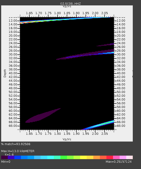
| Estimated Moho Depth: |
13.0 km |
| Estimated Crust Vp/Vs: |
1.60 |
| Assumed Crust Vp: |
6.426 km/s |
| Estimated Crust Vs: |
4.016 km/s |
| Estimated Crust Poisson's Ratio: |
0.18 |
|
| Radial Match: |
93.92586 % |
| Radial Bump: |
373 |
| Transverse Match: |
64.838066 % |
| Transverse Bump: |
400 |
| SOD ConfigId: |
25131211 |
| Insert Time: |
2021-08-12 07:24:17.667 +0000 |
| GWidth: |
2.5 |
| Max Bumps: |
400 |
| Tol: |
0.001 |
|

Signal To Noise
| Channel | StoN | STA | LTA |
| O2:SC08: :HHZ:20210729T06:40:19.35499Z | 1.4849751 | 3.8468608E-4 | 2.590522E-4 |
| O2:SC08: :HHN:20210729T06:40:19.35499Z | 0.88518757 | 2.5912546E-4 | 2.9273512E-4 |
| O2:SC08: :HHE:20210729T06:40:19.35499Z | 2.3614955 | 4.918444E-4 | 2.0827664E-4 |
| Arrivals |
| Ps | 1.3 SECOND |
| PpPs | 4.9 SECOND |
| PsPs/PpSs | 6.2 SECOND |


