You are here: Home > Network List > TX - Texas Seismological Network Stations List
> Station PB07 Mentone > Earthquake Result Viewer
PB07 Mentone - Earthquake Result Viewer
| Earthquake location: |
South Of Alaska |
| Earthquake latitude/longitude: |
54.9/-156.4 |
| Earthquake time(UTC): |
2021/07/29 (210) 06:32:30 GMT |
| Earthquake Depth: |
10 km |
| Earthquake Magnitude: |
5.8 mb |
| Earthquake Catalog/Contributor: |
NEIC PDE/ak |
|
| Network: |
TX Texas Seismological Network |
| Station: |
PB07 Mentone |
| Lat/Lon: |
31.58 N/103.67 W |
| Elevation: |
856 m |
|
| Distance: |
43.6 deg |
| Az: |
100.104 deg |
| Baz: |
318.248 deg |
| Ray Param: |
0.07242939 |
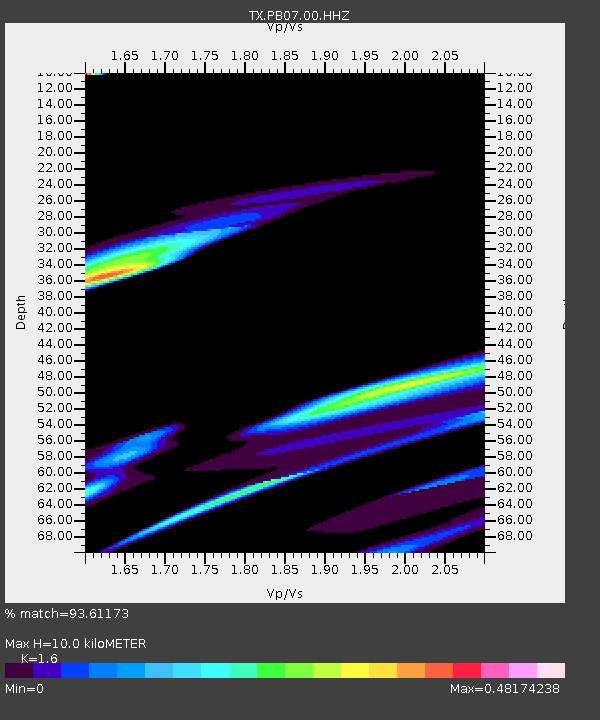
| Estimated Moho Depth: |
10.0 km |
| Estimated Crust Vp/Vs: |
1.60 |
| Assumed Crust Vp: |
6.121 km/s |
| Estimated Crust Vs: |
3.825 km/s |
| Estimated Crust Poisson's Ratio: |
0.18 |
|
| Radial Match: |
93.61173 % |
| Radial Bump: |
400 |
| Transverse Match: |
59.66344 % |
| Transverse Bump: |
400 |
| SOD ConfigId: |
25131211 |
| Insert Time: |
2021-08-12 07:27:48.414 +0000 |
| GWidth: |
2.5 |
| Max Bumps: |
400 |
| Tol: |
0.001 |
|

Signal To Noise
| Channel | StoN | STA | LTA |
| TX:PB07:00:HHZ:20210729T06:40:04.069986Z | 0.60366786 | 1.8250266E-5 | 3.0232299E-5 |
| TX:PB07:00:HH1:20210729T06:40:04.069986Z | 2.5129929 | 3.1829408E-5 | 1.2665937E-5 |
| TX:PB07:00:HH2:20210729T06:40:04.069986Z | 0.623306 | 1.5712341E-5 | 2.5208072E-5 |
| Arrivals |
| Ps | 1.0 SECOND |
| PpPs | 4.0 SECOND |
| PsPs/PpSs | 5.0 SECOND |


