You are here: Home > Network List > TX - Texas Seismological Network Stations List
> Station PH03 Pantex > Earthquake Result Viewer
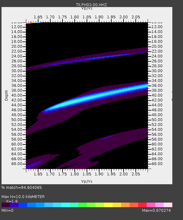
PH03 Pantex - Earthquake Result Viewer
| Earthquake location: |
South Of Alaska |
| Earthquake latitude/longitude: |
54.9/-156.4 |
| Earthquake time(UTC): |
2021/07/29 (210) 06:32:30 GMT |
| Earthquake Depth: |
10 km |
| Earthquake Magnitude: |
5.8 mb |
| Earthquake Catalog/Contributor: |
NEIC PDE/ak |
|
| Network: |
TX Texas Seismological Network |
| Station: |
PH03 Pantex |
| Lat/Lon: |
35.36 N/101.55 W |
| Elevation: |
1061 m |
|
| Distance: |
42.1 deg |
| Az: |
94.413 deg |
| Baz: |
315.238 deg |
| Ray Param: |
0.07337151 |
| Estimated Moho Depth: |
10.0 km |
| Estimated Crust Vp/Vs: |
1.60 |
| Assumed Crust Vp: |
6.426 km/s |
| Estimated Crust Vs: |
4.016 km/s |
| Estimated Crust Poisson's Ratio: |
0.18 |
|
| Radial Match: |
94.604065 % |
| Radial Bump: |
326 |
| Transverse Match: |
76.58939 % |
| Transverse Bump: |
400 |
| SOD ConfigId: |
25131211 |
| Insert Time: |
2021-08-12 07:27:58.538 +0000 |
| GWidth: |
2.5 |
| Max Bumps: |
400 |
| Tol: |
0.001 |
|

Signal To Noise
| Channel | StoN | STA | LTA |
| TX:PH03:00:HHZ:20210729T06:39:51.660013Z | 1.7431898 | 8.8953204E-4 | 5.102898E-4 |
| TX:PH03:00:HH1:20210729T06:39:51.660013Z | 1.4099069 | 4.2669813E-4 | 3.0264276E-4 |
| TX:PH03:00:HH2:20210729T06:39:51.660013Z | 1.3967204 | 6.0251413E-4 | 4.3137776E-4 |
| Arrivals |
| Ps | 1.0 SECOND |
| PpPs | 3.8 SECOND |
| PsPs/PpSs | 4.8 SECOND |


