You are here: Home > Network List > US - United States National Seismic Network Stations List
> Station GLMI Grayling, Michigan, USA > Earthquake Result Viewer
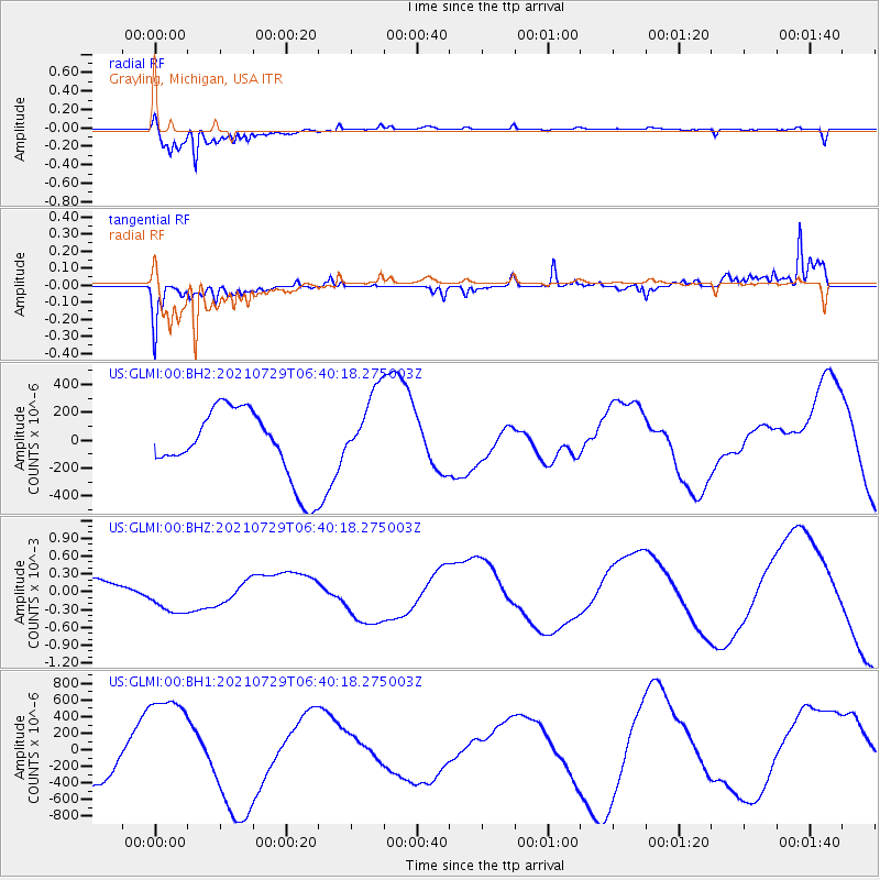
GLMI Grayling, Michigan, USA - Earthquake Result Viewer
*The percent match for this event was below the threshold and hence no stack was calculated.
| Earthquake location: |
South Of Alaska |
| Earthquake latitude/longitude: |
54.9/-156.4 |
| Earthquake time(UTC): |
2021/07/29 (210) 06:32:30 GMT |
| Earthquake Depth: |
10 km |
| Earthquake Magnitude: |
5.8 mb |
| Earthquake Catalog/Contributor: |
NEIC PDE/ak |
|
| Network: |
US United States National Seismic Network |
| Station: |
GLMI Grayling, Michigan, USA |
| Lat/Lon: |
44.82 N/84.62 W |
| Elevation: |
387 m |
|
| Distance: |
45.4 deg |
| Az: |
71.665 deg |
| Baz: |
309.643 deg |
| Ray Param: |
$rayparam |
*The percent match for this event was below the threshold and hence was not used in the summary stack. |
|
| Radial Match: |
96.22973 % |
| Radial Bump: |
322 |
| Transverse Match: |
56.18405 % |
| Transverse Bump: |
351 |
| SOD ConfigId: |
25131211 |
| Insert Time: |
2021-08-12 07:28:23.344 +0000 |
| GWidth: |
2.5 |
| Max Bumps: |
400 |
| Tol: |
0.001 |
|
Signal To Noise
| Channel | StoN | STA | LTA |
| US:GLMI:00:BHZ:20210729T06:40:18.275003Z | 1.9234354 | 2.895004E-4 | 1.5051216E-4 |
| US:GLMI:00:BH1:20210729T06:40:18.275003Z | 3.1427455 | 6.5342255E-4 | 2.0791458E-4 |
| US:GLMI:00:BH2:20210729T06:40:18.275003Z | 1.125623 | 2.787505E-4 | 2.476411E-4 |
| Arrivals |
| Ps | |
| PpPs | |
| PsPs/PpSs | |


