You are here: Home > Network List > US - United States National Seismic Network Stations List
> Station VBMS Vicksburg, Mississippi > Earthquake Result Viewer
VBMS Vicksburg, Mississippi - Earthquake Result Viewer
| Earthquake location: |
South Of Alaska |
| Earthquake latitude/longitude: |
54.9/-156.4 |
| Earthquake time(UTC): |
2021/07/29 (210) 06:32:30 GMT |
| Earthquake Depth: |
10 km |
| Earthquake Magnitude: |
5.8 mb |
| Earthquake Catalog/Contributor: |
NEIC PDE/ak |
|
| Network: |
US United States National Seismic Network |
| Station: |
VBMS Vicksburg, Mississippi |
| Lat/Lon: |
32.22 N/90.52 W |
| Elevation: |
16 m |
|
| Distance: |
50.7 deg |
| Az: |
88.251 deg |
| Baz: |
317.098 deg |
| Ray Param: |
0.06786682 |
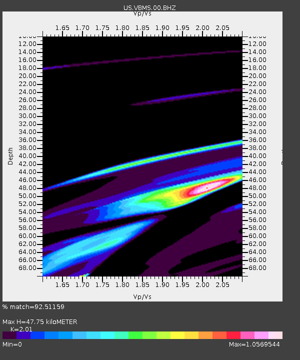
| Estimated Moho Depth: |
47.75 km |
| Estimated Crust Vp/Vs: |
2.01 |
| Assumed Crust Vp: |
6.201 km/s |
| Estimated Crust Vs: |
3.085 km/s |
| Estimated Crust Poisson's Ratio: |
0.34 |
|
| Radial Match: |
92.51159 % |
| Radial Bump: |
400 |
| Transverse Match: |
51.825108 % |
| Transverse Bump: |
400 |
| SOD ConfigId: |
25131211 |
| Insert Time: |
2021-08-12 07:28:37.090 +0000 |
| GWidth: |
2.5 |
| Max Bumps: |
400 |
| Tol: |
0.001 |
|

Signal To Noise
| Channel | StoN | STA | LTA |
| US:VBMS:00:BHZ:20210729T06:40:59.275003Z | 1.7673556 | 2.8791363E-4 | 1.6290645E-4 |
| US:VBMS:00:BH1:20210729T06:40:59.275003Z | 1.7049379 | 3.3932208E-4 | 1.9902312E-4 |
| US:VBMS:00:BH2:20210729T06:40:59.275003Z | 1.1559592 | 4.2902824E-4 | 3.7114476E-4 |
| Arrivals |
| Ps | 8.1 SECOND |
| PpPs | 22 SECOND |
| PsPs/PpSs | 30 SECOND |


