You are here: Home > Network List > XG95 - Nanga Parbat Pakistan Stations List
> Station DMB2 Saralocoto > Earthquake Result Viewer
DMB2 Saralocoto - Earthquake Result Viewer
| Earthquake location: |
Mindanao, Philippines |
| Earthquake latitude/longitude: |
9.4/126.5 |
| Earthquake time(UTC): |
1996/09/20 (264) 12:24:42 GMT |
| Earthquake Depth: |
33 km |
| Earthquake Magnitude: |
5.4 MB, 6.0 MS, 6.3 UNKNOWN, 6.0 MW |
| Earthquake Catalog/Contributor: |
WHDF/NEIC |
|
| Network: |
XG Nanga Parbat Pakistan |
| Station: |
DMB2 Saralocoto |
| Lat/Lon: |
36.18 N/73.19 E |
| Elevation: |
2375 m |
|
| Distance: |
55.1 deg |
| Az: |
307.667 deg |
| Baz: |
105.137 deg |
| Ray Param: |
0.06495921 |
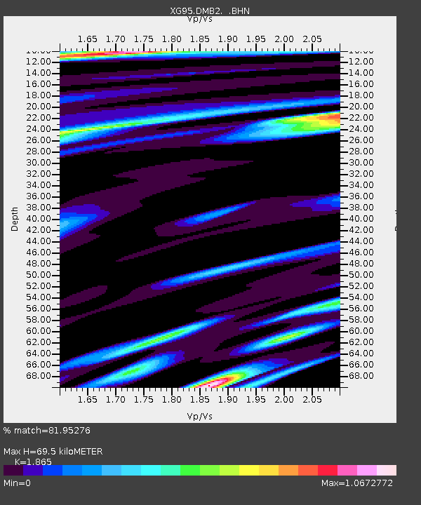
| Estimated Moho Depth: |
69.5 km |
| Estimated Crust Vp/Vs: |
1.87 |
| Assumed Crust Vp: |
6.5 km/s |
| Estimated Crust Vs: |
3.485 km/s |
| Estimated Crust Poisson's Ratio: |
0.30 |
|
| Radial Match: |
81.95276 % |
| Radial Bump: |
400 |
| Transverse Match: |
67.83597 % |
| Transverse Bump: |
400 |
| SOD ConfigId: |
6273 |
| Insert Time: |
2010-03-09 11:04:10.414 +0000 |
| GWidth: |
2.5 |
| Max Bumps: |
400 |
| Tol: |
0.001 |
|

Signal To Noise
| Channel | StoN | STA | LTA |
| XG:DMB2: :BHN:19960920T12:33:40.23501Z | 1.0574613 | 4.2343594E-8 | 4.004269E-8 |
| XG:DMB2: :BHE:19960920T12:33:40.23501Z | 1.4038932 | 9.287627E-8 | 6.6156225E-8 |
| XG:DMB2: :BHZ:19960920T12:33:40.23501Z | 1.995382 | 1.6741251E-7 | 8.3899984E-8 |
| Arrivals |
| Ps | 9.7 SECOND |
| PpPs | 29 SECOND |
| PsPs/PpSs | 39 SECOND |


