You are here: Home > Network List > TA - USArray Transportable Network (new EarthScope stations) Stations List
> Station A36M Sachs Harbour, NT, CAN > Earthquake Result Viewer
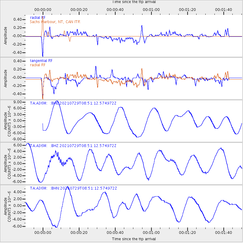
A36M Sachs Harbour, NT, CAN - Earthquake Result Viewer
*The percent match for this event was below the threshold and hence no stack was calculated.
| Earthquake location: |
Myanmar |
| Earthquake latitude/longitude: |
22.9/96.0 |
| Earthquake time(UTC): |
2021/07/29 (210) 08:39:27 GMT |
| Earthquake Depth: |
10 km |
| Earthquake Magnitude: |
5.5 mb |
| Earthquake Catalog/Contributor: |
NEIC PDE/us |
|
| Network: |
TA USArray Transportable Network (new EarthScope stations) |
| Station: |
A36M Sachs Harbour, NT, CAN |
| Lat/Lon: |
71.99 N/125.25 W |
| Elevation: |
32 m |
|
| Distance: |
81.3 deg |
| Az: |
11.979 deg |
| Baz: |
322.027 deg |
| Ray Param: |
$rayparam |
*The percent match for this event was below the threshold and hence was not used in the summary stack. |
|
| Radial Match: |
54.011177 % |
| Radial Bump: |
400 |
| Transverse Match: |
36.218483 % |
| Transverse Bump: |
322 |
| SOD ConfigId: |
25131211 |
| Insert Time: |
2021-08-12 08:47:51.854 +0000 |
| GWidth: |
2.5 |
| Max Bumps: |
400 |
| Tol: |
0.001 |
|
Signal To Noise
| Channel | StoN | STA | LTA |
| TA:A36M: :BHZ:20210729T08:51:12.574972Z | 1.5125537 | 4.3502596E-6 | 2.8761026E-6 |
| TA:A36M: :BHN:20210729T08:51:12.574972Z | 0.9481162 | 3.9397537E-6 | 4.1553494E-6 |
| TA:A36M: :BHE:20210729T08:51:12.574972Z | 0.90553963 | 4.2837305E-6 | 4.730583E-6 |
| Arrivals |
| Ps | |
| PpPs | |
| PsPs/PpSs | |


