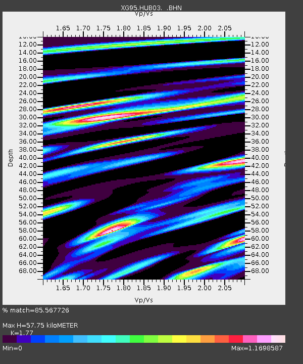
HUB03 Hunza - Earthquake Result Viewer

Earthquake location: Southern Sumatra, Indonesia
Earthquake latitude/longitude: -2.0/99.7
Earthquake time(UTC): 1996/08/09 (222) 00:27:05 GMT
Earthquake Depth: 33 km
Earthquake Magnitude: 5.5 MS, 5.4 MB, 5.8 UNKNOWN, 5.7 MW
Earthquake Catalog/Contributor: WHDF/NEIC
Network: XG Nanga Parbat Pakistan
Station: HUB03 Hunza
Lat/Lon: 36.33 N/74.66 E
Elevation: 2469 m
Distance: 44.7 deg
Az: 330.967 deg
Baz: 143.083 deg
Ray Param: 0.07168566
Estimated Moho Depth: 57.75 km
Estimated Crust Vp/Vs: 1.77
Assumed Crust Vp: 6.481 km/s
Estimated Crust Vs: 3.661 km/s
Estimated Crust Poisson's Ratio: 0.27
Radial Match: 85.567726 %
Radial Bump: 400
Transverse Match: 79.35548 %
Transverse Bump: 400
SOD ConfigId: 4480
Insert Time: 2010-03-09 11:04:57.792 +0000
GWidth: 2.5
Max Bumps: 400
Tol: 0.001

Signal To Noise

ChannelStoNSTALTA
XG:HUB03: :BHN:19960809T00:34:45.307013Z5.5433625.1086823E-79.215855E-8
XG:HUB03: :BHE:19960809T00:34:45.307013Z2.2236351.615679E-77.265936E-8
XG:HUB03: :BHZ:19960809T00:34:45.307013Z2.41126821.7590898E-77.2952886E-8
Arrivals
Ps7.3 SECOND
PpPs23 SECOND
PsPs/PpSs30 SECOND