You are here: Home > Network List > US - United States National Seismic Network Stations List
> Station WUAZ Wupatki, Arizona, USA > Earthquake Result Viewer
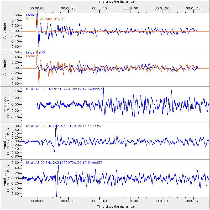
WUAZ Wupatki, Arizona, USA - Earthquake Result Viewer
*The percent match for this event was below the threshold and hence no stack was calculated.
| Earthquake location: |
South Of Alaska |
| Earthquake latitude/longitude: |
55.3/-156.9 |
| Earthquake time(UTC): |
2021/07/29 (210) 20:32:44 GMT |
| Earthquake Depth: |
45 km |
| Earthquake Magnitude: |
5.5 ml |
| Earthquake Catalog/Contributor: |
NEIC PDE/ak |
|
| Network: |
US United States National Seismic Network |
| Station: |
WUAZ Wupatki, Arizona, USA |
| Lat/Lon: |
35.52 N/111.37 W |
| Elevation: |
1592 m |
|
| Distance: |
36.7 deg |
| Az: |
103.324 deg |
| Baz: |
316.967 deg |
| Ray Param: |
$rayparam |
*The percent match for this event was below the threshold and hence was not used in the summary stack. |
|
| Radial Match: |
74.16826 % |
| Radial Bump: |
400 |
| Transverse Match: |
65.27984 % |
| Transverse Bump: |
400 |
| SOD ConfigId: |
25131211 |
| Insert Time: |
2021-08-12 20:53:07.987 +0000 |
| GWidth: |
2.5 |
| Max Bumps: |
400 |
| Tol: |
0.001 |
|
Signal To Noise
| Channel | StoN | STA | LTA |
| US:WUAZ:00:BHZ:20210729T20:39:17.649995Z | 1.7518492 | 8.7408914E-8 | 4.9895224E-8 |
| US:WUAZ:00:BH1:20210729T20:39:17.649995Z | 2.002611 | 1.07714E-7 | 5.3786785E-8 |
| US:WUAZ:00:BH2:20210729T20:39:17.649995Z | 1.4727731 | 8.07235E-8 | 5.481055E-8 |
| Arrivals |
| Ps | |
| PpPs | |
| PsPs/PpSs | |


