You are here: Home > Network List > CI - Caltech Regional Seismic Network Stations List
> Station BAR Barrett, Tecate, CA, USA > Earthquake Result Viewer
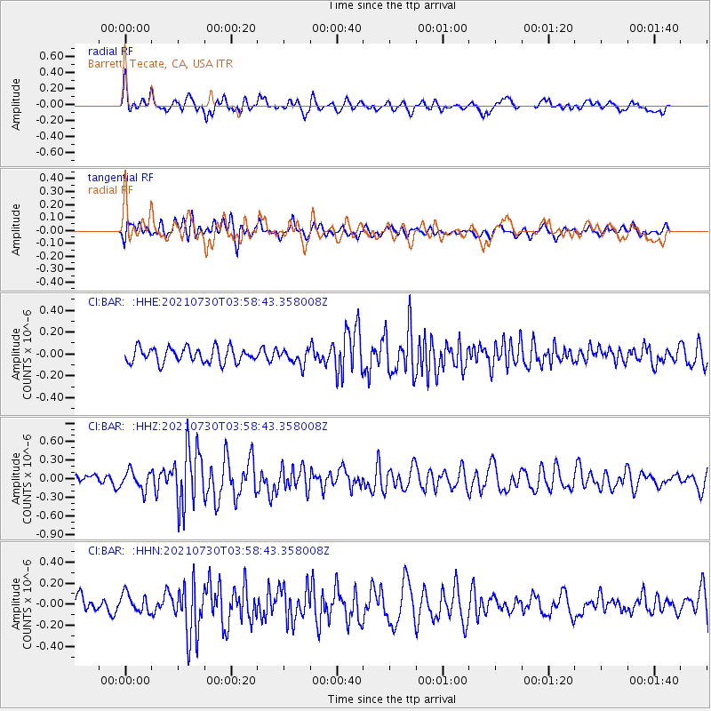
BAR Barrett, Tecate, CA, USA - Earthquake Result Viewer
*The percent match for this event was below the threshold and hence no stack was calculated.
| Earthquake location: |
South Of Alaska |
| Earthquake latitude/longitude: |
55.4/-157.0 |
| Earthquake time(UTC): |
2021/07/30 (211) 03:52:15 GMT |
| Earthquake Depth: |
33 km |
| Earthquake Magnitude: |
5.5 Mww |
| Earthquake Catalog/Contributor: |
NEIC PDE/ak |
|
| Network: |
CI Caltech Regional Seismic Network |
| Station: |
BAR Barrett, Tecate, CA, USA |
| Lat/Lon: |
32.68 N/116.67 W |
| Elevation: |
521 m |
|
| Distance: |
36.1 deg |
| Az: |
112.055 deg |
| Baz: |
321.122 deg |
| Ray Param: |
$rayparam |
*The percent match for this event was below the threshold and hence was not used in the summary stack. |
|
| Radial Match: |
68.04823 % |
| Radial Bump: |
400 |
| Transverse Match: |
62.49153 % |
| Transverse Bump: |
400 |
| SOD ConfigId: |
25131211 |
| Insert Time: |
2021-08-13 03:54:19.648 +0000 |
| GWidth: |
2.5 |
| Max Bumps: |
400 |
| Tol: |
0.001 |
|
Signal To Noise
| Channel | StoN | STA | LTA |
| CI:BAR: :HHZ:20210730T03:58:43.358008Z | 2.3139062 | 1.525392E-7 | 6.592281E-8 |
| CI:BAR: :HHN:20210730T03:58:43.358008Z | 1.3432329 | 8.972235E-8 | 6.679582E-8 |
| CI:BAR: :HHE:20210730T03:58:43.358008Z | 0.98470896 | 6.702055E-8 | 6.8061276E-8 |
| Arrivals |
| Ps | |
| PpPs | |
| PsPs/PpSs | |


